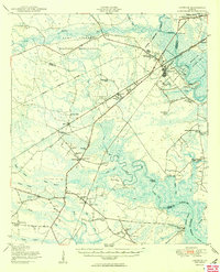
1950 Map of Limerick
USGS Topo · Published 1950About this map
The Medway River and the coastal marshes of Liberty and Bryan Counties define this mid-century landscape, where river-driven commerce meets military expansion. Along the northern border, the Camp Stewart Military Reservation consumes large tracts of land above the Canoochee River. The map documents a dense network of community infrastructure, including the Dorchester Academy and numerous rural schools such as the George Washington Carver School and Dixie Daniel School. The settlement pattern follows the Atlantic Coast Line and Seaboard Air Line railroads, connecting towns like Limerick and Richmond Hill. Near the coast, the historical importance of the region is evident at Sunbury and the site of Fort Morris, while the complex hydrology is marked by the Peachtree Canal and Valambrosa Canal, reflecting generations of drainage and agricultural engineering in the lowcountry.
Find a feature on this map
85 named features on this map. Tap any name to fly to it.
Don’t see what you’re looking for? This feature index may not catch every label — zoom into the map to look around manually.
Map Details
Editions of this 1950 Limerick Map
2 editions found
Other maps of this area

1918 · Hinesville
USGS Topo · 1:62,500

1920 · Pembroke
USGS Topo · 1:62,500

1920 · Meldrim
USGS Topo · 1:62,500

1920 · Sapelo River
USGS Topo · 1:62,500

1920 · Limerick
USGS Topo · 1:62,500

1928 · St Catherines Island
USGS Topo · 1:62,500

1942 · Meldrim
USGS Topo · 1:62,500

1942 · Savannah
USGS Topo · 1:62,500

1943 · Ludowici
USGS Topo · 1:62,500

1943 · St Catherines Island
USGS Topo · 1:62,500