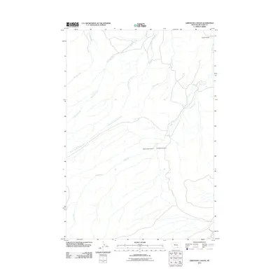
2011 Map of Limestone Canyon
USGS Topo · Published 2011About this map
Limestone Canyon and Soap Creek Canyon define the drainage patterns of this Big Horn County landscape. The area is defined by a complex network of waterways, with Soap Creek serving as the central artery for several tributaries. The topographic detail reveals how the land transitions from the high ridges down toward Goose Coulee in the northeast corner. Modern infrastructure is limited to routes like Soap Creek Rd, emphasizing the rural and undeveloped nature of this Montana territory in the early 21st century. Significant water features including War Man Creek, West Soap Creek, and Deer Creek carve through the terrain, illustrating the natural erosion that has shaped the canyons over time.
Find a feature on this map
10 named features on this map. Tap any name to fly to it.
Don’t see what you’re looking for? This feature index may not catch every label — zoom into the map to look around manually.
Map Details
Editions of this 2011 Limestone Canyon Map
This is the sole edition of this map. No revisions or reprints were ever made.
Other maps of this area

1894 · St. Xavier
USGS Topo · 1:125,000

1901 · St. Xavier
USGS Topo · 1:125,000

1954 · Hardin
USGS Topo · 1:250,000

1957 · Hardin
USGS Topo · 1:250,000

1958 · Hardin
USGS Topo · 1:250,000

1960 · Mission Coulee
USGS Topo · 1:24,000

1964 · Peyote Point
USGS Topo · 1:24,000
1964 · Mountain Pocket Creek
USGS Topo · 1:24,000
1964 · Yellowtail Dam
USGS Topo · 1:24,000
1969 · Willow Creek Dam SW
USGS Topo · 1:24,000