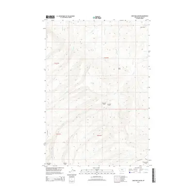
2014 Map of Limestone Canyon
USGS Topo · Published 2014About this map
Limestone Canyon and Soap Creek Canyon dominate this part of Big Horn County, where high Montana ridges are dissected by an intricate drainage system. The landscape is defined by the headwaters of several streams, including Soap Cr and War-Man Cr, which carve deep paths through the terrain. Human presence is sparse, marked primarily by isolated routes such as Black Canyon Rd and Sawlog Rd that navigate the high country. To the northeast, the landform transitions at Goose Coulee, while the southern reaches of the quadrangle reveal the beginnings of Rotten Grass Canyon. This survey illustrates a remote ranching or wilderness environment where geographic features like Deer Cr and W Soap Cr are the primary landmarks for navigation across the township and range boundaries of t7s r32e and t8s r32e.
Find a feature on this map
16 named features on this map. Tap any name to fly to it.
Don’t see what you’re looking for? This feature index may not catch every label — zoom into the map to look around manually.
Map Details
Editions of this 2014 Limestone Canyon Map
This is the sole edition of this map. No revisions or reprints were ever made.
Other maps of this area

1894 · St. Xavier
USGS Topo · 1:125,000

1901 · St. Xavier
USGS Topo · 1:125,000

1954 · Hardin
USGS Topo · 1:250,000

1957 · Hardin
USGS Topo · 1:250,000

1958 · Hardin
USGS Topo · 1:250,000

1960 · Mission Coulee
USGS Topo · 1:24,000

1964 · Peyote Point
USGS Topo · 1:24,000
1964 · Mountain Pocket Creek
USGS Topo · 1:24,000
1964 · Yellowtail Dam
USGS Topo · 1:24,000
1969 · Willow Creek Dam SW
USGS Topo · 1:24,000