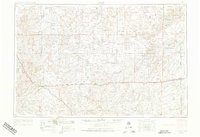
1954 Map of Limon
USGS Topo · Published 1974About this map
The High Plains of eastern Colorado and western Kansas are defined by a network of braided rivers and heavy rail lines in this mid-century survey. The landscape is dominated by the Arickaree River and the three forks of the Republican River, which drain the arid expanses of the Sand Hills. A primary corridor of settlement follows the Chicago Rock Island and Pacific railroad, linking towns like Limon, Flagler, and Burlington.
Find a feature on this map
72 named features on this map. Tap any name to fly to it.
Don’t see what you’re looking for? This feature index may not catch every label — zoom into the map to look around manually.
Map Details
Editions of this 1954 Limon Map
4 editions found

Other maps of this area

1889 · Sanborn
USGS Topo · 1:125,000

1891 · Sanborn
USGS Topo · 1:125,000

1891 · Arroyo
USGS Topo · 1:125,000

1891 · Kit Carson
USGS Topo · 1:125,000

1891 · Limon
USGS Topo · 1:125,000

1892 · Limon
USGS Topo · 1:125,000

1892 · Cheyenne Wells
USGS Topo · 1:125,000

1893 · Arroyo
USGS Topo · 1:125,000

1893 · Kit Carson
USGS Topo · 1:125,000

1893 · Sanborn
USGS Topo · 1:125,000