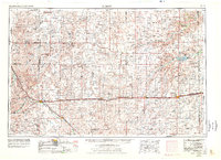
1954 Map of Limon
USGS Topo · Published 1978About this map
The High Plains of Eastern Colorado and Western Kansas are defined here by a network of ranching settlements and critical rail corridors. Centered on Limon, the map illustrates a landscape where the Chicago Rock Island & Pacific and Union Pacific railroads dictate the placement of towns like Genoa, Arriba, and Flagler. The terrain is characterized by the extensive Sand Hills and the winding drainages of the South Fork Republican River and Big Sandy Creek. Small crossroads such as Last Chance and Anton appear alongside larger hubs like Burlington, which sits near the state line. This 1970s revision, based on earlier surveys, captures the region's mid-century rural character, documenting numerous unnamed cemeteries and gravel pits that supported local infrastructure. The transition from the plains into the Kansas borderlands is marked by the presence of Kanorado, showing how these settlements functioned as vital links in a rail-and-river economy.
Find a feature on this map
56 named features on this map. Tap any name to fly to it.
Don’t see what you’re looking for? This feature index may not catch every label — zoom into the map to look around manually.
Map Details
Editions of this 1954 Limon Map
4 editions found

Other maps of this area

1889 · Sanborn
USGS Topo · 1:125,000

1891 · Sanborn
USGS Topo · 1:125,000

1891 · Arroyo
USGS Topo · 1:125,000

1891 · Kit Carson
USGS Topo · 1:125,000

1891 · Limon
USGS Topo · 1:125,000

1892 · Limon
USGS Topo · 1:125,000

1892 · Cheyenne Wells
USGS Topo · 1:125,000

1893 · Arroyo
USGS Topo · 1:125,000

1893 · Kit Carson
USGS Topo · 1:125,000

1893 · Sanborn
USGS Topo · 1:125,000