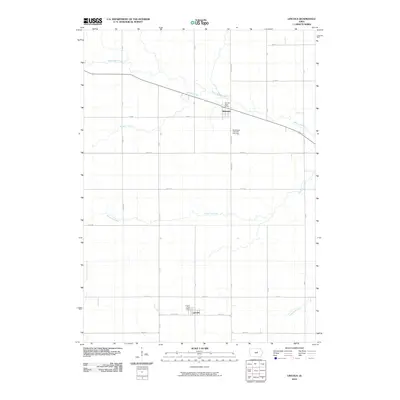
2010 Map of Lincoln
USGS Topo · Published 2010About this map
The small settlements of Lincoln and Morrison anchor this agricultural landscape in Grundy and Tama Counties during the early 21st century. The terrain is defined by a dense network of watercourses, including the meandering Black Hawk Creek and Mosquito Creek, which flow through a structured grid of rural roads like Tama Rd and 260th St. This 2010 survey reflects a deeply established farming community where civic life remains centered on local institutions such as the Lincoln Post Office and Morrison Post Office. Genealogists will find particular value in the documentation of the Washington Township Cemetery, located south of Morrison along N Morrison. The map also captures the intricate drainage system of the region, tracing the paths of Fourmile Creek, Munns Creek, and Twelvemile Creek as they traverse the section lines of the Iowa countryside.
Find a feature on this map
33 named features on this map. Tap any name to fly to it.
Don’t see what you’re looking for? This feature index may not catch every label — zoom into the map to look around manually.
Map Details
Editions of this 2010 Lincoln Map
This is the sole edition of this map. No revisions or reprints were ever made.
Other maps of this area

1954 · Waterloo
USGS Topo · 1:250,000

1955 · Waterloo
USGS Topo · 1:250,000

1960 · Marshalltown
USGS Topo · 1:62,500

1960 · Conrad East
USGS Topo · 1:24,000

1971 · Gladbrook NE
USGS Topo · 1:24,000

1971 · Zaneta
USGS Topo · 1:24,000

1971 · Dike
USGS Topo · 1:24,000

1971 · Lincoln
USGS Topo · 1:24,000

1971 · Reinbeck
USGS Topo · 1:24,000
1971 · Gladbrook
USGS Topo · 1:24,000