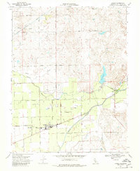
1968 Map of Linden
USGS Topo · Published 1980About this map
The town of Linden sits at the heart of this late-1960s agricultural landscape, serving as a hub for the local fruit and nut orchards of San Joaquin County. The Stockton Terminal and Eastern railroad corridor reaches into the settlement, terminating near the High School and Junior High School, reflecting the vital connection between the valley's growers and broader markets. This era shows the complex water management of the Central Valley, with the Calaveras River and Mormon Slough providing essential irrigation, while the massive Aqueduct cuts through the northern portion of the quadrangle.
Find a feature on this map
38 named features on this map. Tap any name to fly to it.
Don’t see what you’re looking for? This feature index may not catch every label — zoom into the map to look around manually.
Map Details
Editions of this 1968 Linden Map
3 editions found
Other maps of this area

1889 · Jackson
USGS Topo · 1:125,000

1892 · Jackson
USGS Topo · 1:125,000

1894 · Lodi
USGS Topo · 1:125,000

1897 · Jackson
USGS Topo · 1:125,000

1902 · Jackson
USGS Topo · 1:125,000

1908 · Waterloo
USGS Topo · 1:31,680

1908 · Linden
USGS Topo · 1:31,680

1908 · Lockeford
USGS Topo · 1:31,680

1909 · Clements
USGS Topo · 1:31,680

1914 · Burnham
USGS Topo · 1:31,680