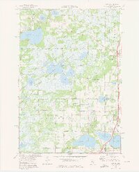
1974 Map of Linwood
USGS Topo · Published 1976About this map
The Carlos Avery State Wildlife Management Area dominates the central landscape of this mid-1970s survey, illustrating a vast protected wetland and forest complex where the Sunrise River South Branch meanders. This conservation-focused terrain is bordered by the developing communities of Linwood, Wyoming, and the northern edges of Forest Lake. The map reveals a transition from natural resource management to local township life, evidenced by the presence of an Old Railroad Grade and several local institutions.
Find a feature on this map
43 named features on this map. Tap any name to fly to it.
Don’t see what you’re looking for? This feature index may not catch every label — zoom into the map to look around manually.
Map Details
Editions of this 1974 Linwood Map
3 editions found
Other maps of this area

1902 · White Bear
USGS Topo · 1:62,500

1948 · Stillwater
USGS Topo · 1:62,500

1949 · Stillwater
USGS Topo · 1:62,500

1952 · Centerville
USGS Topo · 1:24,000

1953 · Stillwater
USGS Topo · 1:250,000

1954 · Hugo
USGS Topo · 1:24,000

1955 · Circle Pines
USGS Topo · 1:24,000

1955 · Forest Lake
USGS Topo · 1:62,500

1955 · Isanti
USGS Topo · 1:62,500
1955 · New Brighton
USGS Topo · 1:62,500