
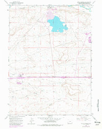
1961 Map of Little America
USGS Topo · Published 1964About this map
The intersection of early western migration and 20th-century industrial infrastructure is evident across this part of Sweetwater County. The historic Overland Trail cuts across the northern landscape, running parallel to the Union Pacific railroad and the waters of Blacks Fork. This area, surveyed in the early 1960s, reveals a terrain defined by resource extraction and utility corridors, featuring the Westvaco Shaft No 3 and the industrial activity of Westvaco.
Find a feature on this map
21 named features on this map. Tap any name to fly to it.
Don’t see what you’re looking for? This feature index may not catch every label — zoom into the map to look around manually.
Map Details
Editions of this 1961 Little America Map
2 editions found
Other maps of this area

1954 · Rock Springs
USGS Topo · 1:250,000

1957 · Mc Kinnon Junction
USGS Topo · 1:62,500

1958 · Rock Springs
USGS Topo · 1:250,000

1961 · Blue Point
USGS Topo · 1:24,000

1961 · Sevenmile Gulch
USGS Topo · 1:24,000

1961 · Granger
USGS Topo · 1:24,000

1961 · Stevens Flat
USGS Topo · 1:24,000

1961 · Bryan
USGS Topo · 1:24,000

1962 · Rock Springs
USGS Topo · 1:250,000

1964 · Antelope Knoll NE
USGS Topo · 1:24,000