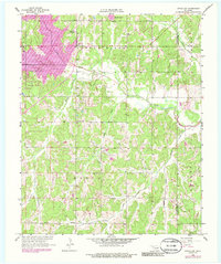
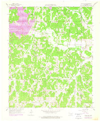
1958 Map of Little Axe
USGS Topo · Published 1986About this map
Little River and its numerous tributaries, including Hog Creek and Roulette Creek, define the topography of this central Oklahoma landscape. In the late 1950s, the area retained a rural, service-oriented character centered on small settlements like Little Axe and Needmore. The map records an active Oil Field and scattered Oil Wells, indicating the region's reliance on mineral extraction alongside traditional agricultural pursuits. Significant social anchors are represented by the Little Jim Mission in the north and country churches such as Bennett Ch and Etowah Ch. These landmarks, along with Bethel Cem and Mars Hill Cem, provide essential data points for those tracing family history in the area near the Cleveland County and Pottawatomie County line. The inclusion of Little River State Park in the west highlights the early development of managed recreation areas prior to the major reservoir expansions seen in later decades.
Find a feature on this map
24 named features on this map. Tap any name to fly to it.
Don’t see what you’re looking for? This feature index may not catch every label — zoom into the map to look around manually.
Map Details
Editions of this 1958 Little Axe Map
5 editions found
Other maps of this area

1892 · Moore
USGS Topo · 1:62,500

1893 · Norman
USGS Topo · 1:62,500

1898 · Purcell
USGS Topo · 1:125,000

1910 · McComb
USGS Topo · 1:62,500

1930 · McLoud
USGS Topo · 1:62,500

1934 · Moore
USGS Topo · 1:62,500

1936 · Norman
USGS Topo · 1:62,500

1938 · Moore
USGS Topo · 1:62,500

1954 · Oklahoma City
USGS Topo · 1:250,000
1956 · Franklin
USGS Topo · 1:24,000