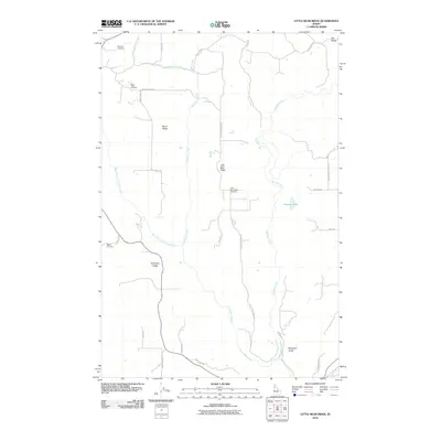
2010 Map of Little Bear Ridge
USGS Topo · Published 2010About this map
Little Bear Ridge and the surrounding high ground of Nez Perce County are defined by a series of prominent geographic fingers including American Ridge, Burnt Ridge, and Dry Ridge. This 2010 survey shows a landscape dominated by upland agriculture and the deep incisions of Big Bear Creek and the West Fork Little Bear Creek. For family historians, the map is particularly valuable for its documentation of rural burial grounds that anchor the local ridges, such as Spencer Cemetery in the north and the Little Bear Ridge Cemetery near the center of the quadrangle. The road network, including Burnt Ridge Rd and American Ridge Rd, follows the natural contours of the land, illustrating how the topography dictated the development of homesteads and transport in this part of Idaho. Notable water features like Atwater Lake and drainage points like McCloud Gulch provide additional landmarks for locating specific historic properties.
Find a feature on this map
31 named features on this map. Tap any name to fly to it.
Don’t see what you’re looking for? This feature index may not catch every label — zoom into the map to look around manually.
Map Details
Editions of this 2010 Little Bear Ridge Map
This is the sole edition of this map. No revisions or reprints were ever made.
Other maps of this area

1955 · Pullman
USGS Topo · 1:250,000

1958 · Pullman
USGS Topo · 1:250,000

1960 · Troy
USGS Topo · 1:24,000

1960 · Moscow Mtn
USGS Topo · 1:24,000

1960 · Potlatch
USGS Topo · 1:62,500

1961 · Deary
USGS Topo · 1:62,500

1961 · Kendrick
USGS Topo · 1:62,500

1961 · Moscow
USGS Topo · 1:62,500

1981 · Potlatch
USGS Topo · 1:100,000
1990 · Juliaetta
USGS Topo · 1:24,000