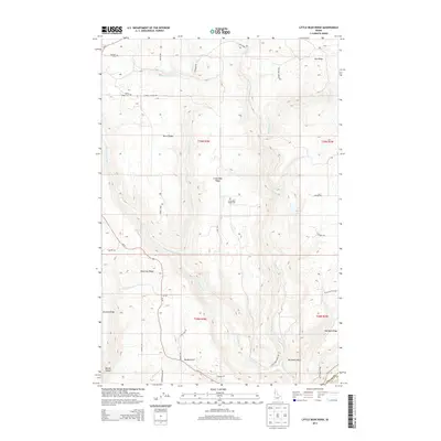
2013 Map of Little Bear Ridge
USGS Topo · Published 2013About this map
Little Bear Ridge and its neighboring plateaus define this corner of the Idaho panhandle, where steep drainages separate long, flat fingers of land used for agriculture. The terrain is divided by several significant watercourses, including the Big Bear Cr and its tributaries such as Little Bear Cr and the W Fork Little Bear Cr. This 2013 survey provides essential data for genealogists and local historians, locating several family-named landmarks and rural burial grounds such as Spencer Cem, Burnt Ridge Cem, and the Little Bear Ridge Cem.
Find a feature on this map
41 named features on this map. Tap any name to fly to it.
Don’t see what you’re looking for? This feature index may not catch every label — zoom into the map to look around manually.
Map Details
Editions of this 2013 Little Bear Ridge Map
This is the sole edition of this map. No revisions or reprints were ever made.
Other maps of this area

1955 · Pullman
USGS Topo · 1:250,000

1958 · Pullman
USGS Topo · 1:250,000

1960 · Troy
USGS Topo · 1:24,000

1960 · Moscow Mtn
USGS Topo · 1:24,000

1960 · Potlatch
USGS Topo · 1:62,500

1961 · Deary
USGS Topo · 1:62,500

1961 · Kendrick
USGS Topo · 1:62,500

1961 · Moscow
USGS Topo · 1:62,500

1981 · Potlatch
USGS Topo · 1:100,000
1990 · Juliaetta
USGS Topo · 1:24,000