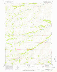
1965 Map of Little Dee Creek
USGS Topo · Published 1979About this map
Ryckman Spring and its namesake Ryckman Creek anchor the northern reaches of this high-elevation landscape in Uinta County. The terrain is defined by a series of significant drainages, including the central path of Little Dee Creek and the southern flow of Shurtleff Creek. These natural water sources were essential landmarks in an area dominated by open range and public land surveys. Topographic details reveal the complex network of draws and ridges, such as Haystack Draw and the various springs feeding into Clear Creek. The map provides a precise record of the township and range lines across this corner of Wyoming, showing the intersect of Township 17 North and Township 16 North, offering valuable data for researchers tracing historical land boundaries or grazing patterns in the late twentieth century.
Find a feature on this map
12 named features on this map. Tap any name to fly to it.
Don’t see what you’re looking for? This feature index may not catch every label — zoom into the map to look around manually.
Map Details
Editions of this 1965 Little Dee Creek Map
3 editions found
Other maps of this area

1954 · Ogden
USGS Topo · 1:250,000

1958 · Ogden
USGS Topo · 1:250,000

1960 · Ogden
USGS Topo · 1:250,000

1962 · Sawtooth Mountain
USGS Topo · 1:24,000

1962 · Elkol SW
USGS Topo · 1:24,000

1962 · Bell Butte
USGS Topo · 1:24,000

1965 · Evanston
USGS Topo · 1:24,000

1965 · Ragan
USGS Topo · 1:24,000

1965 · Little Dee Creek
USGS Topo · 1:24,000

1965 · Meadow Draw
USGS Topo · 1:24,000