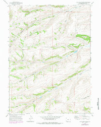
1965 Map of Little Dee Creek
USGS Topo · Published 1984About this map
Ryckman Spring and a network of high-desert water sources define this corner of Uinta County during the mid-1960s. The landscape is dominated by a complex system of drainages, including the headwaters of Little Dee Creek and the meandering Ryckman Creek. These riparian corridors provided essential water for livestock and wildlife in a region marked by significant elevation changes, as indicated by the dense contour lines throughout the quadrangle.
Find a feature on this map
11 named features on this map. Tap any name to fly to it.
Don’t see what you’re looking for? This feature index may not catch every label — zoom into the map to look around manually.
Map Details
Editions of this 1965 Little Dee Creek Map
3 editions found
Other maps of this area

1954 · Ogden
USGS Topo · 1:250,000

1958 · Ogden
USGS Topo · 1:250,000

1960 · Ogden
USGS Topo · 1:250,000

1962 · Sawtooth Mountain
USGS Topo · 1:24,000

1962 · Elkol SW
USGS Topo · 1:24,000

1962 · Bell Butte
USGS Topo · 1:24,000

1965 · Evanston
USGS Topo · 1:24,000

1965 · Ragan
USGS Topo · 1:24,000

1965 · Little Dee Creek
USGS Topo · 1:24,000

1965 · Meadow Draw
USGS Topo · 1:24,000