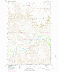
1956 Map of Little Eagle
USGS Topo · Published 1978About this map
Little Eagle sits at the heart of this mid-century survey, located within the Standing Rock Indian Reservation along the northern banks of the Grand River. The community's spiritual and social infrastructure is anchored by St Pauls Ch and the nearby St Pauls Cem, illustrating the importance of these local institutions in the rural Plains landscape. The topography is dominated by the sharp bend of the river and the prominent Elk Butte to the northeast, which provides a significant landmark in an area otherwise defined by river breaks and plateau terrain.
Find a feature on this map
11 named features on this map. Tap any name to fly to it.
Don’t see what you’re looking for? This feature index may not catch every label — zoom into the map to look around manually.
Map Details
Editions of this 1956 Little Eagle Map
2 editions found
Other maps of this area

1953 · McIntosh
USGS Topo · 1:250,000

1956 · Little Eagle SW
USGS Topo · 1:24,000

1956 · Wakpala NW
USGS Topo · 1:24,000

1956 · Little Eagle
USGS Topo · 1:24,000

1956 · Little Eagle SE
USGS Topo · 1:24,000

1956 · Little Eagle NW
USGS Topo · 1:24,000

1956 · Wakpala SW
USGS Topo · 1:24,000

1958 · McIntosh
USGS Topo · 1:250,000

1966 · McLaughlin
USGS Topo · 1:24,000

1966 · Mahto
USGS Topo · 1:24,000