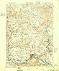
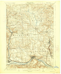
1903 Map of Little Falls
USGS Topo · Published 1932About this map
The Mohawk River corridor serves as the industrial and transportation spine of this region during the turn of the century, where the Erie Canal and Barge Canal parallel major rail lines. The city of Little Falls anchors the southern landscape, showing a dense network of streets and infrastructure concentrated at the river's narrows. To the east, the village of Dolgeville sits along Spruce Creek, which feeds down from the uplands near Salisbury. This 1898 survey, reprinted in the early 1930s, documents the transition of transportation technology, noting an abandoned segment of the West Shore RR near Danube. Further north, the landscape shifts toward rural hill country, characterized by family-named landmarks like Dairy Hill and Barto Hill and small crossroads such as Norway and Fairfield. Historical markers like Fort Herkimer and the Herkimer Monument highlight the deep colonial and revolutionary roots of this valley.
Find a feature on this map
55 named features on this map. Tap any name to fly to it.
Don’t see what you’re looking for? This feature index may not catch every label — zoom into the map to look around manually.
Map Details
Editions of this 1903 Little Falls Map
6 editions found

Other maps of this area

1897 · Remsen
USGS Topo · 1:62,500

1898 · Utica
USGS Topo · 1:62,500

1898 · Canajoharie
USGS Topo · 1:62,500

1900 · Little Falls
USGS Topo · 1:62,500

1900 · Utica
USGS Topo · 1:62,500

1900 · Canajoharie
USGS Topo · 1:62,500

1900 · Remsen
USGS Topo · 1:62,500

1900 · Wilmurt
USGS Topo · 1:62,500

1901 · Lassellsville
USGS Topo · 1:62,500

1902 · Canajoharie
USGS Topo · 1:62,500