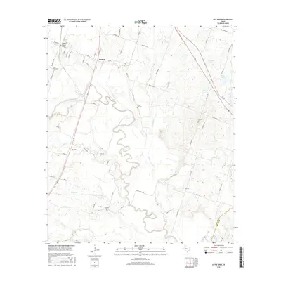
2016 Map of Little River
USGS Topo · Published 2016About this map
The Little River meanders deeply through this central Texas landscape, creating a complex series of oxbows and bends that define the topography between Little River and Academy. This 2016 survey captures a primarily rural and agricultural district where small communities like Sparks are linked by a network of farm-to-market roads and local lanes. The map is particularly valuable for genealogical research, documenting several dispersed burial sites including Little River Cem, Volo Cem, and Sunshine Cem. Elevated terrain features like Knob Hill overlook the river valley, while various tributaries such as Knob Cr and Georgia Br drain the surrounding fields. The eastern portion of the quadrangle shows localized water management with Lansham Lake and Prewitt Lake 5, contrasting with the more natural, winding course of the main waterway.
Find a feature on this map
70 named features on this map. Tap any name to fly to it.
Don’t see what you’re looking for? This feature index may not catch every label — zoom into the map to look around manually.
Map Details
Editions of this 2016 Little River Map
This is the sole edition of this map. No revisions or reprints were ever made.
Other maps of this area

1885 · Taylor
USGS Topo · 1:125,000

1887 · Taylor
USGS Topo · 1:125,000

1892 · Temple
USGS Topo · 1:125,000

1894 · Taylor
USGS Topo · 1:125,000

1910 · Buckholts
USGS Topo · 1:24,000

1912 · Buckholts
USGS Topo · 1:31,680

1924 · Temple 3-C
USGS Topo · 1:48,000

1931 · Belton
USGS Topo · 1:62,500

1954 · Waco
USGS Topo · 1:250,000

1954 · Austin
USGS Topo · 1:250,000
Featured Places
- Little River-Academy, TX
- Sparks, TX
- Joe Lee, TX
- Little River, Little River-Academy
- Academy, Little River-Academy