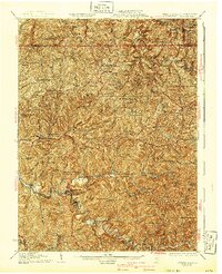
1926 Map of Littleton
USGS Topo · Published 1940About this map
The Baltimore and Ohio RR cuts through the northeast corner of this 1920s landscape, serving the community of Littleton. This territory at the junction of Marshall and Wetzel counties is defined by a dense network of ridges and runs, where small rural schools and churches anchored a dispersed agricultural society. Significant clusters of habitation appear along the banks of Fishing Creek, where towns like Jacksonburg, Pine Grove, and Hastings sit between the rising slopes of Victory Ridge and Howard Ridge. Small, family-named landmarks such as Higgins Chapel and Allen Chapel are scattered throughout the hills, while numerous one-room schoolhouses like Greenfield School and Antioch School illustrate the localized nature of early 20th-century education. The geography of the region is traced through its intricate waterways, from the North Fork to Little Fishing Creek, which dictated the placement of early settlements like Wileyville and Allister.
Find a feature on this map
176 named features on this map. Tap any name to fly to it.
Don’t see what you’re looking for? This feature index may not catch every label — zoom into the map to look around manually.
Map Details
Editions of this 1926 Littleton Map
2 editions found

Other maps of this area

1902 · Clarksburg
USGS Topo · 1:62,500

1903 · Littleton
USGS Topo · 1:62,500

1904 · Cameron
USGS Topo · 1:62,500

1905 · Mannington
USGS Topo · 1:62,500

1905 · Rogersville
USGS Topo · 1:62,500

1905 · Centerpoint
USGS Topo · 1:62,500

1905 · West Union
USGS Topo · 1:62,500

1905 · Littleton
USGS Topo · 1:62,500

1905 · Clarington
USGS Topo · 1:62,500

1906 · New Martinsville
USGS Topo · 1:62,500