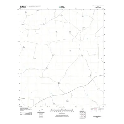
2010 Map of Live Oak Ranch
USGS Topo · Published 2010About this map
Live Oak Ranch and other sprawling pastoral properties define this section of the Texas Hill Country as it appeared in the early 21st century. The landscape is characterized by its reliance on well water and wind power, evidenced by a dense network of specifically named landmarks such as Goat Shed Windmill, Steel Pens Windmill, and White Point Windmill. These features indicate a deeply managed grazing environment where water access dictates the movement of livestock. In the southern portion of the survey, the drainage of Bear Creek provides a natural hydrological contrast to the upland windmill sites. Other significant named operations like Black Bull Ranch and Wolf Proof Ranch speak to the specialized cattle and predator-management practices of the region, while the Game Warden Windmill reflects the intersection of private land use and conservation oversight.
Find a feature on this map
22 named features on this map. Tap any name to fly to it.
Don’t see what you’re looking for? This feature index may not catch every label — zoom into the map to look around manually.
Map Details
Editions of this 2010 Live Oak Ranch Map
This is the sole edition of this map. No revisions or reprints were ever made.
Other maps of this area

1894 · Kerrville
USGS Topo · 1:125,000

1954 · Llano
USGS Topo · 1:250,000

1955 · Llano
USGS Topo · 1:250,000

1956 · Llano
USGS Topo · 1:250,000

1963 · Garven Store
USGS Topo · 1:24,000

1963 · Y O Ranch
USGS Topo · 1:24,000

1964 · Boneyard Draw
USGS Topo · 1:24,000
1964 · Contrary Creek
USGS Topo · 1:24,000
1964 · Bee Caves Creek
USGS Topo · 1:24,000

1964 · Live Oak Ranch
USGS Topo · 1:24,000