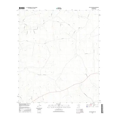
2016 Map of Live Oak Ranch
USGS Topo · Published 2016About this map
Live Oak Ranch occupies a central position in this portion of the Texas Hill Country, where ranching interests and private landholdings define the rural geography. The landscape is characterized by a dense network of private ranch roads and trails, such as E Camino Real Rd, Hyatt Mill Rd, and Black Bull Rd, which weave through the rolling elevation. The primary drainage for the area is Bear Cr, which flows through the southeastern quadrant near Ponda Rosa Ranch Rd. This 2016 survey illustrates the modern configuration of these large estates, including the Henry Priour Ranch Rd W and the E Y O Ranch Rd. The predominance of named ranch roads over traditional town settlements reflects the region's enduring character as a territory of large-scale land ownership and restricted-access thoroughfares.
Find a feature on this map
25 named features on this map. Tap any name to fly to it.
Don’t see what you’re looking for? This feature index may not catch every label — zoom into the map to look around manually.
Map Details
Editions of this 2016 Live Oak Ranch Map
This is the sole edition of this map. No revisions or reprints were ever made.
Other maps of this area

1894 · Kerrville
USGS Topo · 1:125,000

1954 · Llano
USGS Topo · 1:250,000

1955 · Llano
USGS Topo · 1:250,000

1956 · Llano
USGS Topo · 1:250,000

1963 · Garven Store
USGS Topo · 1:24,000

1963 · Y O Ranch
USGS Topo · 1:24,000

1964 · Boneyard Draw
USGS Topo · 1:24,000
1964 · Contrary Creek
USGS Topo · 1:24,000
1964 · Bee Caves Creek
USGS Topo · 1:24,000

1964 · Live Oak Ranch
USGS Topo · 1:24,000