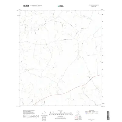
2019 Map of Live Oak Ranch
USGS Topo · Published 2019About this map
Live Oak Ranch sits atop the high, dissected plateau of the Texas Hill Country, anchoring a landscape defined more by its private holdings and winding ranch roads than by dense settlements. The drainage of Bear Cr carves through the southeast, while the upland terrain is partitioned by an extensive network of named tracks and trails. Historical routes like E Camino Real Rd and Hyatt Mill Rd trace the ridges, suggesting a long-standing pattern of pastoral land use. The presence of modern thoroughfares like Fm 1340 and property-specific roads such as Henry Priour Ranch Rd W and Ponda Rosa Ranch Rd highlights the area's contemporary character as a region of expansive ranching estates and rural homesteads.
Find a feature on this map
25 named features on this map. Tap any name to fly to it.
Don’t see what you’re looking for? This feature index may not catch every label — zoom into the map to look around manually.
Map Details
Editions of this 2019 Live Oak Ranch Map
This is the sole edition of this map. No revisions or reprints were ever made.
Other maps of this area

1894 · Kerrville
USGS Topo · 1:125,000

1954 · Llano
USGS Topo · 1:250,000

1955 · Llano
USGS Topo · 1:250,000

1956 · Llano
USGS Topo · 1:250,000

1963 · Garven Store
USGS Topo · 1:24,000

1963 · Y O Ranch
USGS Topo · 1:24,000

1964 · Boneyard Draw
USGS Topo · 1:24,000
1964 · Contrary Creek
USGS Topo · 1:24,000
1964 · Bee Caves Creek
USGS Topo · 1:24,000

1964 · Live Oak Ranch
USGS Topo · 1:24,000