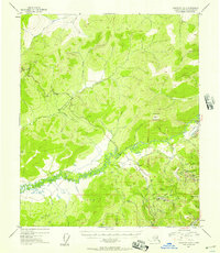
1954 Map of Livengood A-2
USGS Topo · Published 1957About this map
The Chatanika River valley and its surrounding interior peaks define this mid-century look at the Fairbanks District, showing the infrastructure of a landscape shaped by mining and early road development. Following the curves of the river, an Old Railroad Grade and an extensive Ditch system trace the history of large-scale gold recovery efforts that once powered the regional economy. The Elliott Highway winds through the hills, connecting isolated outposts and camps located along the many tributary streams. Settlement patterns are focused near these water sources, with small nodes like Old Chatanika, Olnes, and several company stations including Dome Camp and Pedro Camp. Notable heights such as Haystack Mountain and Pedro Dome provide significant landmarks, while evocatively named drainages like Discontented Pup and Last Chance Creek reflect the prospecting heritage of the region.
Find a feature on this map
40 named features on this map. Tap any name to fly to it.
Don’t see what you’re looking for? This feature index may not catch every label — zoom into the map to look around manually.
Map Details
Editions of this 1954 Livengood A-2 Map
2 editions found
Other maps of this area

1945 · Livengood
USGS Topo · 1:250,000

1949 · Fairbanks D-1
USGS Topo · 1:62,500

1949 · Fairbanks D-2
USGS Topo · 1:62,500

1949 · Fairbanks D-3
USGS Topo · 1:63,360

1950 · Fairbanks
USGS Topo · 1:250,000

1950 · Fairbanks D-3
USGS Topo · 1:63,360

1951 · Fairbanks
USGS Topo · 1:250,000

1951 · Livengood
USGS Topo · 1:250,000

1951 · Livengood B-2
USGS Topo · 1:63,360

1952 · Fairbanks D-2
USGS Topo · 1:63,360