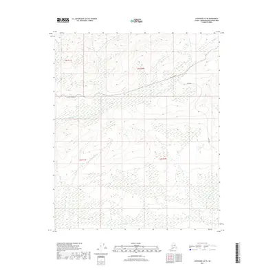
2017 Map of Livengood A-6 NE
USGS Topo · Published 2017About this map
Elliott Highway traverses the northern highlands of this interior Alaska landscape, providing a critical transportation link through the Yukon-Koyukuk region. In the years following its initial construction to serve the gold fields, this corridor remained a vital artery for the region's scattered settlements. To the south, Minto Road branches off, winding through the expansive wetlands and drainages that characterize the southern half of this quadrangle. The topography is defined by the descent from upland ridges toward the low-lying basins of Hutlitakwa Cr and Lochenhuttli Cr. Other notable drainages including Uncle Sam Cr and Moose Cr illustrate the complex hydrography of the Alaskan bush, where seasonal water flow and permafrost dictate the patterns of human access and land use within the township boundaries of t5n r11w and t4n r10w.
Find a feature on this map
10 named features on this map. Tap any name to fly to it.
Don’t see what you’re looking for? This feature index may not catch every label — zoom into the map to look around manually.
Map Details
Editions of this 2017 Livengood A-6 NE Map
This is the sole edition of this map. No revisions or reprints were ever made.
Other maps of this area

1945 · Livengood
USGS Topo · 1:250,000

1951 · Livengood
USGS Topo · 1:250,000

1951 · Livengood A-5
USGS Topo · 1:63,360

1952 · Livengood A-6
USGS Topo · 1:63,360

1952 · Livengood B-5
USGS Topo · 1:63,360

1953 · Livengood A-6
USGS Topo · 1:63,360
1954 · Livengood A-5
USGS Topo · 1:63,360

1956 · Livengood B-6
USGS Topo · 1:63,360

1956 · Livengood
USGS Topo · 1:250,000

1964 · Livengood
USGS Topo · 1:250,000