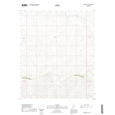
2017 Map of Livengood B-1 SE
USGS Topo · Published 2017About this map
Nome Creek winds through the northern reaches of this interior Alaskan landscape, which is defined by the boundary between the Yukon-Koyukuk Census Area and the Fairbanks North Star Borough. The terrain is characterized by a dense network of watercourses, including Ophir Cr, McKay Cr, and Boston Cr, which drain the complex topography. Access into this interior region is primarily represented by the Nome Creek W Road, which tracks alongside the namesake creek in the northeast. The map provides a detailed view of the Public Land Survey System grid, spanning Townships 5 and 6 North and Ranges 2 through 4 East, capturing the intersection of administrative divisions in a largely roadless territory save for this single primary corridor and a few minor tracks like those near Long Cr.
Find a feature on this map
13 named features on this map. Tap any name to fly to it.
Don’t see what you’re looking for? This feature index may not catch every label — zoom into the map to look around manually.
Map Details
Editions of this 2017 Livengood B-1 SE Map
This is the sole edition of this map. No revisions or reprints were ever made.
Other maps of this area

1945 · Livengood
USGS Topo · 1:250,000

1951 · Livengood
USGS Topo · 1:250,000

1951 · Circle
USGS Topo · 1:250,000

1952 · Livengood A-1
USGS Topo · 1:63,360

1954 · Circle A-6
USGS Topo · 1:63,360

1954 · Circle B-6
USGS Topo · 1:63,360

1954 · Livengood B-1
USGS Topo · 1:63,360
1954 · Livengood A-1
USGS Topo · 1:63,360

1955 · Circle
USGS Topo · 1:250,000

1956 · Livengood
USGS Topo · 1:250,000