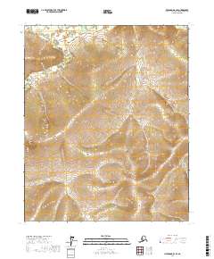
2017 Map of Livengood B-2 SE
USGS Topo · Published 2017About this map
Wickersham Cr flows through the northern reaches of this interior Alaskan landscape, a region defined by high ridges and the deep drainages of the Yukon-Koyukuk. The terrain is organized by the Public Land Survey System, with the intersection of t6n r1w, t6n r1e, t5n r1w, and t5n r1e meeting at the center of the sheet. This area is characterized by significant topographic relief, where narrow creek valleys like Moose Cr and Trail Cr cut through the uplands. The absence of roads or established settlements in this 2017 survey highlights the remote character of the subarctic wilderness north of Fairbanks, where the landscape remains shaped primarily by its natural watercourses and the underlying geology of the interior.
Find a feature on this map
7 named features on this map. Tap any name to fly to it.
Don’t see what you’re looking for? This feature index may not catch every label — zoom into the map to look around manually.
Map Details
Editions of this 2017 Livengood B-2 SE Map
This is the sole edition of this map. No revisions or reprints were ever made.
Other maps of this area

1945 · Livengood
USGS Topo · 1:250,000

1951 · Livengood
USGS Topo · 1:250,000

1951 · Livengood B-2
USGS Topo · 1:63,360

1952 · Livengood A-2
USGS Topo · 1:63,360

1952 · Livengood A-1
USGS Topo · 1:63,360
1954 · Livengood B-2
USGS Topo · 1:63,360
1954 · Livengood A-2
USGS Topo · 1:63,360

1954 · Livengood B-1
USGS Topo · 1:63,360
1954 · Livengood A-1
USGS Topo · 1:63,360

1956 · Livengood
USGS Topo · 1:250,000