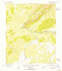
1954 Map of Livengood B-2
USGS Topo · Published 1955About this map
The White Mountains dominate this 1954 topographic study within the Alaska-Fourth Judicial Division, revealing a landscape where high ridgelines overlook a complex drainage network. The serpentine course of Beaver Creek carves through the central terrain, supported by tributaries such as Fossil Creek and Montana Creek. These waterways, along with the Tatalina River in the northwest, provided the primary corridors for movement in an area largely devoid of formal roads.
Find a feature on this map
15 named features on this map. Tap any name to fly to it.
Don’t see what you’re looking for? This feature index may not catch every label — zoom into the map to look around manually.
Map Details
Editions of this 1954 Livengood B-2 Map
2 editions found
Other maps of this area

1945 · Livengood
USGS Topo · 1:250,000

1951 · Livengood
USGS Topo · 1:250,000

1951 · Livengood C-2
USGS Topo · 1:63,360

1951 · Livengood C-1
USGS Topo · 1:63,360

1951 · Livengood B-2
USGS Topo · 1:63,360

1952 · Livengood A-2
USGS Topo · 1:63,360

1952 · Livengood A-1
USGS Topo · 1:63,360

1953 · Livengood A-3
USGS Topo · 1:63,360

1954 · Livengood C-2
USGS Topo · 1:63,360

1954 · Livengood C-1
USGS Topo · 1:63,360