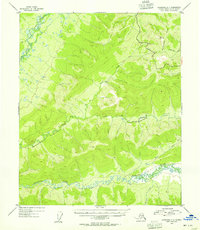
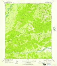
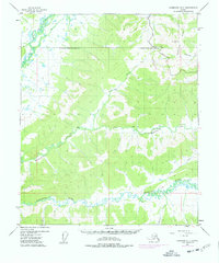
1953 Map of Livengood A-3
USGS Topo · Published 1955About this map
The Chatanika River dominates the southern landscape of this interior Alaskan territory, its braided channels and oxbows revealing the dynamic nature of this subarctic watershed. In the early 1950s, the Elliott Highway serves as the primary artery for travel, winding through the northeastern corner near the prominence of Wickersham Dome. The terrain is defined by a dense network of drainages including Washington Creek and Aggie Creek, which cut through the uplands before joining the larger river systems.
Find a feature on this map
12 named features on this map. Tap any name to fly to it.
Don’t see what you’re looking for? This feature index may not catch every label — zoom into the map to look around manually.
Map Details
Editions of this 1953 Livengood A-3 Map
4 editions found
Historical Maps of Unorganized Borough Through Time
340 maps found

1949 Big Delta B-5
Fairbanks North Star Borough, AK

1949 Big Delta B-6
Fairbanks North Star Borough, AK

1949 Big Delta C-6
Fairbanks North Star Borough, AK

1949 Fairbanks C-1
Fairbanks North Star Borough, AK

1949 Fairbanks C-2
Fairbanks North Star Borough, AK

1949 Fairbanks D-1
Fairbanks North Star Borough, AK

1949 Fairbanks D-2
Fairbanks North Star Borough, AK

1949 Fairbanks D-3
Fairbanks North Star Borough, AK

1950 Big Delta D-6
Fairbanks North Star Borough, AK

1950 Fairbanks B-1
Fairbanks North Star Borough, AK

1950 Fairbanks B-2
Fairbanks North Star Borough, AK

1950 Fairbanks C-1
Fairbanks North Star Borough, AK

1950 Fairbanks C-3
Fairbanks North Star Borough, AK

1950 Fairbanks D-3
Fairbanks North Star Borough, AK

1951 Circle A-5
Fairbanks North Star Borough, AK

1951 Fairbanks B-1
Fairbanks North Star Borough, AK

1951 Fairbanks B-2
Fairbanks North Star Borough, AK

1952 Big Delta B-5
Fairbanks North Star Borough, AK

1952 Big Delta B-6
Fairbanks North Star Borough, AK

1952 Big Delta C-6
Fairbanks North Star Borough, AK

1952 Big Delta D-6
Fairbanks North Star Borough, AK

1952 Circle A-4
Fairbanks North Star Borough, AK

1952 Circle A-5
Fairbanks North Star Borough, AK

1952 Fairbanks C-1
Fairbanks North Star Borough, AK

1952 Fairbanks C-2
Fairbanks North Star Borough, AK

1952 Fairbanks C-3
Fairbanks North Star Borough, AK

1952 Fairbanks D-1
Fairbanks North Star Borough, AK

1952 Fairbanks D-2
Fairbanks North Star Borough, AK

1952 Fairbanks D-3
Fairbanks North Star Borough, AK

1952 Livengood A-1
Fairbanks North Star Borough, AK

1952 Livengood A-2
Fairbanks North Star Borough, AK

1953 Livengood A-3
Fairbanks North Star Borough, AK

1954 Circle A-5
Fairbanks North Star Borough, AK

1954 Circle A-6
Fairbanks North Star Borough, AK

1954 Circle B-5
Fairbanks North Star Borough, AK

1954 Fairbanks D-2
Fairbanks North Star Borough, AK

1954 Livengood A-1
Fairbanks North Star Borough, AK

1954 Livengood A-2
Fairbanks North Star Borough, AK

1955 Fairbanks D-2
Fairbanks North Star Borough, AK

1958 Big Delta C-2
Fairbanks North Star Borough, AK

1958 Big Delta C-3
Fairbanks North Star Borough, AK

1958 Big Delta C-4
Fairbanks North Star Borough, AK

1958 Big Delta C-5
Fairbanks North Star Borough, AK

1958 Big Delta D-1
Fairbanks North Star Borough, AK

1958 Big Delta D-2
Fairbanks North Star Borough, AK

1958 Big Delta D-3
Fairbanks North Star Borough, AK

1958 Big Delta D-4
Fairbanks North Star Borough, AK

1958 Big Delta D-5
Fairbanks North Star Borough, AK

1965 Fairbanks D-2
Fairbanks North Star Borough, AK

1966 Fairbanks D-1 SW
Fairbanks North Star Borough, AK

1966 Fairbanks D-2 NE
Fairbanks North Star Borough, AK

1966 Fairbanks D-2 NW
Fairbanks North Star Borough, AK

1966 Fairbanks D-2 SE
Fairbanks North Star Borough, AK

1966 Fairbanks D-2 SW
Fairbanks North Star Borough, AK

1973 Big Delta D-3
Fairbanks North Star Borough, AK

1992 Big Delta B-6 NW
Fairbanks North Star Borough, AK

1992 Big Delta C-6 NW
Fairbanks North Star Borough, AK

1992 Big Delta C-6 SW
Fairbanks North Star Borough, AK

1992 Big Delta D-6 NW
Fairbanks North Star Borough, AK

1992 Big Delta D-6 SW
Fairbanks North Star Borough, AK

1992 Fairbanks C-1 NE
Fairbanks North Star Borough, AK

1992 Fairbanks C-1 NW
Fairbanks North Star Borough, AK

1992 Fairbanks C-1 SE
Fairbanks North Star Borough, AK

1992 Fairbanks D-1 NE
Fairbanks North Star Borough, AK

1992 Fairbanks D-1 NW
Fairbanks North Star Borough, AK

1992 Fairbanks D-1 SE
Fairbanks North Star Borough, AK

1992 Fairbanks D-1 SW
Fairbanks North Star Borough, AK

1992 Fairbanks D-2 NE
Fairbanks North Star Borough, AK

1992 Fairbanks D-2 NW
Fairbanks North Star Borough, AK

1992 Fairbanks D-2 SE
Fairbanks North Star Borough, AK

1992 Fairbanks D-2 SW
Fairbanks North Star Borough, AK

1992 Fairbanks D-3 NE
Fairbanks North Star Borough, AK

1992 Fairbanks D-3 SE
Fairbanks North Star Borough, AK

1992 Fairbanks D-3 SW
Fairbanks North Star Borough, AK

1992 Livengood A-1 SE
Fairbanks North Star Borough, AK

1992 Livengood A-1 SW
Fairbanks North Star Borough, AK

1992 Livengood A-2 SE
Fairbanks North Star Borough, AK

2013 Big Delta B-6 NW
Fairbanks North Star Borough, AK

2013 Big Delta B-6 SW
Fairbanks North Star Borough, AK

2013 Fairbanks B-1 NE
Fairbanks North Star Borough, AK

2013 Fairbanks B-1 NW
Fairbanks North Star Borough, AK

2013 Fairbanks B-1 SE
Fairbanks North Star Borough, AK

2013 Fairbanks B-1 SW
Fairbanks North Star Borough, AK

2013 Fairbanks B-2 NE
Fairbanks North Star Borough, AK

2013 Fairbanks B-2 NW
Fairbanks North Star Borough, AK

2013 Fairbanks B-2 SE
Fairbanks North Star Borough, AK

2013 Fairbanks B-2 SW
Fairbanks North Star Borough, AK

2013 Fairbanks B-3 NE
Fairbanks North Star Borough, AK

2013 Fairbanks C-2 NE
Fairbanks North Star Borough, AK

2013 Fairbanks C-2 NW
Fairbanks North Star Borough, AK

2013 Fairbanks C-2 SE
Fairbanks North Star Borough, AK

2013 Fairbanks C-2 SW
Fairbanks North Star Borough, AK

2013 Fairbanks C-3 NE
Fairbanks North Star Borough, AK

2013 Fairbanks C-3 NW
Fairbanks North Star Borough, AK

2013 Fairbanks C-3 SE
Fairbanks North Star Borough, AK

2013 Fairbanks C-3 SW
Fairbanks North Star Borough, AK

2013 Fairbanks D-2 NW
Fairbanks North Star Borough, AK

2013 Fairbanks D-2 SW
Fairbanks North Star Borough, AK

2013 Fairbanks D-3 NE
Fairbanks North Star Borough, AK

2013 Fairbanks D-3 NW
Fairbanks North Star Borough, AK

2013 Fairbanks D-3 SE
Fairbanks North Star Borough, AK

2013 Fairbanks D-3 SW
Fairbanks North Star Borough, AK

2016 Big Delta B-5 NE
Fairbanks North Star Borough, AK

2016 Big Delta B-5 NW
Fairbanks North Star Borough, AK

2016 Big Delta B-5 SW
Fairbanks North Star Borough, AK

2016 Big Delta B-6 NE
Fairbanks North Star Borough, AK

2016 Big Delta B-6 SE
Fairbanks North Star Borough, AK

2016 Big Delta C-3 NE
Fairbanks North Star Borough, AK

2016 Big Delta C-3 NW
Fairbanks North Star Borough, AK

2016 Big Delta C-3 SE
Fairbanks North Star Borough, AK

2016 Big Delta C-3 SW
Fairbanks North Star Borough, AK

2016 Big Delta C-4 NE
Fairbanks North Star Borough, AK

2016 Big Delta C-4 NW
Fairbanks North Star Borough, AK

2016 Big Delta C-4 SE
Fairbanks North Star Borough, AK

2016 Big Delta C-4 SW
Fairbanks North Star Borough, AK

2016 Big Delta C-5 NE
Fairbanks North Star Borough, AK

2016 Big Delta C-5 NW
Fairbanks North Star Borough, AK

2016 Big Delta C-5 SE
Fairbanks North Star Borough, AK

2016 Big Delta C-5 SW
Fairbanks North Star Borough, AK

2016 Big Delta C-6 NE
Fairbanks North Star Borough, AK

2016 Big Delta C-6 NW
Fairbanks North Star Borough, AK

2016 Big Delta C-6 SE
Fairbanks North Star Borough, AK

2016 Big Delta C-6 SW
Fairbanks North Star Borough, AK

2016 Big Delta D-3 NE
Fairbanks North Star Borough, AK

2016 Big Delta D-3 NW
Fairbanks North Star Borough, AK

2016 Big Delta D-3 SE
Fairbanks North Star Borough, AK

2016 Big Delta D-3 SW
Fairbanks North Star Borough, AK

2016 Big Delta D-4 NE
Fairbanks North Star Borough, AK

2016 Big Delta D-4 NW
Fairbanks North Star Borough, AK

2016 Big Delta D-4 SE
Fairbanks North Star Borough, AK

2016 Big Delta D-4 SW
Fairbanks North Star Borough, AK

2016 Big Delta D-5 NE
Fairbanks North Star Borough, AK

2016 Big Delta D-5 NW
Fairbanks North Star Borough, AK

2016 Big Delta D-5 SE
Fairbanks North Star Borough, AK

2016 Big Delta D-5 SW
Fairbanks North Star Borough, AK

2016 Big Delta D-6 NE
Fairbanks North Star Borough, AK

2016 Big Delta D-6 NW
Fairbanks North Star Borough, AK

2016 Big Delta D-6 SE
Fairbanks North Star Borough, AK

2016 Big Delta D-6 SW
Fairbanks North Star Borough, AK

2016 Fairbanks C-1 NE
Fairbanks North Star Borough, AK

2016 Fairbanks C-1 NW
Fairbanks North Star Borough, AK

2016 Fairbanks C-1 SE
Fairbanks North Star Borough, AK

2016 Fairbanks C-1 SW
Fairbanks North Star Borough, AK

2016 Fairbanks D-1 NE
Fairbanks North Star Borough, AK

2016 Fairbanks D-1 NW
Fairbanks North Star Borough, AK

2016 Fairbanks D-1 SE
Fairbanks North Star Borough, AK

2016 Fairbanks D-1 SW
Fairbanks North Star Borough, AK

2017 Chandalar A-1 SW
Fairbanks North Star Borough, AK

2017 Fairbanks D-2 NE
Fairbanks North Star Borough, AK

2017 Fairbanks D-2 SE
Fairbanks North Star Borough, AK

2017 Livengood A-1 NE
Fairbanks North Star Borough, AK

2017 Livengood A-1 NW
Fairbanks North Star Borough, AK

2017 Livengood A-1 SW
Fairbanks North Star Borough, AK

2017 Livengood A-2 NE
Fairbanks North Star Borough, AK

2017 Livengood A-2 NW
Fairbanks North Star Borough, AK

2017 Livengood A-2 SE
Fairbanks North Star Borough, AK

2017 Livengood A-2 SW
Fairbanks North Star Borough, AK

2017 Livengood A-3 NE
Fairbanks North Star Borough, AK

2017 Livengood A-3 NW
Fairbanks North Star Borough, AK

2017 Livengood A-3 SE
Fairbanks North Star Borough, AK

2017 Livengood A-3 SW
Fairbanks North Star Borough, AK

2017 Livengood A-4 NE
Fairbanks North Star Borough, AK

2017 Livengood A-4 SE
Fairbanks North Star Borough, AK

2018 Big Delta C-1 NE
Fairbanks North Star Borough, AK

2018 Big Delta C-1 NW
Fairbanks North Star Borough, AK

2018 Big Delta C-2 NE
Fairbanks North Star Borough, AK

2018 Big Delta C-2 NW
Fairbanks North Star Borough, AK

2018 Big Delta D-1 NE
Fairbanks North Star Borough, AK

2018 Big Delta D-1 NW
Fairbanks North Star Borough, AK

2018 Big Delta D-1 SE
Fairbanks North Star Borough, AK

2018 Big Delta D-1 SW
Fairbanks North Star Borough, AK

2018 Big Delta D-2 NE
Fairbanks North Star Borough, AK

2018 Big Delta D-2 NW
Fairbanks North Star Borough, AK

2018 Big Delta D-2 SE
Fairbanks North Star Borough, AK

2018 Big Delta D-2 SW
Fairbanks North Star Borough, AK

2018 Charley River A-6 SW
Fairbanks North Star Borough, AK

2018 Circle A-1 SE
Fairbanks North Star Borough, AK

2018 Circle A-1 SW
Fairbanks North Star Borough, AK

2018 Circle A-2 SE
Fairbanks North Star Borough, AK

2018 Circle A-2 SW
Fairbanks North Star Borough, AK

2018 Circle A-3 SE
Fairbanks North Star Borough, AK

2018 Circle A-3 SW
Fairbanks North Star Borough, AK

2018 Circle A-4 NW
Fairbanks North Star Borough, AK

2018 Circle A-4 SW
Fairbanks North Star Borough, AK

2018 Circle A-5 NE
Fairbanks North Star Borough, AK

2018 Circle A-5 NW
Fairbanks North Star Borough, AK

2018 Circle A-5 SE
Fairbanks North Star Borough, AK

2018 Circle A-5 SW
Fairbanks North Star Borough, AK

2018 Circle A-6 NE
Fairbanks North Star Borough, AK

2018 Circle A-6 NW
Fairbanks North Star Borough, AK

2018 Circle A-6 SE
Fairbanks North Star Borough, AK

2018 Circle A-6 SW
Fairbanks North Star Borough, AK

2018 Circle B-5 NW
Fairbanks North Star Borough, AK

2018 Circle B-5 SW
Fairbanks North Star Borough, AK

2018 Circle B-6 NE
Fairbanks North Star Borough, AK

2018 Circle B-6 SE
Fairbanks North Star Borough, AK

2018 Livengood A-1 SE
Fairbanks North Star Borough, AK

2021 Big Delta B-5 SW
Fairbanks North Star Borough, AK

2021 Big Delta B-6 NE
Fairbanks North Star Borough, AK

2021 Big Delta B-6 NW
Fairbanks North Star Borough, AK

2021 Big Delta B-6 SE
Fairbanks North Star Borough, AK

2021 Big Delta B-6 SW
Fairbanks North Star Borough, AK

2021 Big Delta C-4 NE
Fairbanks North Star Borough, AK

2021 Big Delta C-4 NW
Fairbanks North Star Borough, AK

2021 Big Delta C-5 SE
Fairbanks North Star Borough, AK

2021 Big Delta C-5 SW
Fairbanks North Star Borough, AK

2021 Big Delta C-6 NW
Fairbanks North Star Borough, AK

2021 Big Delta C-6 SE
Fairbanks North Star Borough, AK

2021 Big Delta C-6 SW
Fairbanks North Star Borough, AK

2021 Big Delta D-5 NE
Fairbanks North Star Borough, AK

2021 Big Delta D-5 NW
Fairbanks North Star Borough, AK

2021 Big Delta D-6 NE
Fairbanks North Star Borough, AK

2021 Big Delta D-6 NW
Fairbanks North Star Borough, AK

2021 Big Delta D-6 SE
Fairbanks North Star Borough, AK

2021 Big Delta D-6 SW
Fairbanks North Star Borough, AK

2021 Circle A-5 SE
Fairbanks North Star Borough, AK

2021 Fairbanks B-1 NE
Fairbanks North Star Borough, AK

2021 Fairbanks C-1 NE
Fairbanks North Star Borough, AK

2021 Fairbanks C-1 NW
Fairbanks North Star Borough, AK

2021 Fairbanks C-1 SE
Fairbanks North Star Borough, AK

2021 Fairbanks C-3 NE
Fairbanks North Star Borough, AK

2021 Fairbanks C-3 NW
Fairbanks North Star Borough, AK

2021 Fairbanks D-1 NE
Fairbanks North Star Borough, AK

2021 Fairbanks D-1 NW
Fairbanks North Star Borough, AK

2021 Fairbanks D-1 SE
Fairbanks North Star Borough, AK

2021 Fairbanks D-1 SW
Fairbanks North Star Borough, AK

2021 Fairbanks D-2 NE
Fairbanks North Star Borough, AK

2021 Fairbanks D-2 NW
Fairbanks North Star Borough, AK

2021 Fairbanks D-2 SE
Fairbanks North Star Borough, AK

2021 Fairbanks D-2 SW
Fairbanks North Star Borough, AK

2021 Fairbanks D-3 NE
Fairbanks North Star Borough, AK

2021 Fairbanks D-3 NW
Fairbanks North Star Borough, AK

2021 Fairbanks D-3 SE
Fairbanks North Star Borough, AK

2021 Fairbanks D-3 SW
Fairbanks North Star Borough, AK

2021 Livengood A-1 NE
Fairbanks North Star Borough, AK

2021 Livengood A-1 NW
Fairbanks North Star Borough, AK

2021 Livengood A-1 SE
Fairbanks North Star Borough, AK

2021 Livengood A-1 SW
Fairbanks North Star Borough, AK

2021 Livengood A-2 NE
Fairbanks North Star Borough, AK

2021 Livengood A-2 NW
Fairbanks North Star Borough, AK

2021 Livengood A-2 SE
Fairbanks North Star Borough, AK

2021 Livengood A-2 SW
Fairbanks North Star Borough, AK

2021 Livengood A-3 NE
Fairbanks North Star Borough, AK

2021 Livengood A-3 SE
Fairbanks North Star Borough, AK

2021 Livengood A-3 SW
Fairbanks North Star Borough, AK

2024 Big Delta B-5 NE
Fairbanks North Star Borough, AK

2024 Big Delta B-5 NW
Fairbanks North Star Borough, AK

2024 Big Delta B-5 SW
Fairbanks North Star Borough, AK

2024 Big Delta B-6 NE
Fairbanks North Star Borough, AK

2024 Big Delta B-6 SE
Fairbanks North Star Borough, AK

2024 Big Delta C-1 NE
Fairbanks North Star Borough, AK

2024 Big Delta C-1 NW
Fairbanks North Star Borough, AK

2024 Big Delta C-2 NE
Fairbanks North Star Borough, AK

2024 Big Delta C-2 NW
Fairbanks North Star Borough, AK

2024 Big Delta C-3 NE
Fairbanks North Star Borough, AK

2024 Big Delta C-3 NW
Fairbanks North Star Borough, AK

2024 Big Delta C-3 SE
Fairbanks North Star Borough, AK

2024 Big Delta C-3 SW
Fairbanks North Star Borough, AK

2024 Big Delta C-4 NE
Fairbanks North Star Borough, AK

2024 Big Delta C-4 NW
Fairbanks North Star Borough, AK

2024 Big Delta C-4 SE
Fairbanks North Star Borough, AK

2024 Big Delta C-4 SW
Fairbanks North Star Borough, AK

2024 Big Delta C-5 NE
Fairbanks North Star Borough, AK

2024 Big Delta C-5 NW
Fairbanks North Star Borough, AK

2024 Big Delta C-5 SE
Fairbanks North Star Borough, AK

2024 Big Delta C-5 SW
Fairbanks North Star Borough, AK

2024 Big Delta C-6 NE
Fairbanks North Star Borough, AK

2024 Big Delta C-6 NW
Fairbanks North Star Borough, AK

2024 Big Delta C-6 SE
Fairbanks North Star Borough, AK

2024 Big Delta D-1 NE
Fairbanks North Star Borough, AK

2024 Big Delta D-1 NW
Fairbanks North Star Borough, AK

2024 Big Delta D-1 SE
Fairbanks North Star Borough, AK

2024 Big Delta D-1 SW
Fairbanks North Star Borough, AK

2024 Big Delta D-2 NE
Fairbanks North Star Borough, AK

2024 Big Delta D-2 NW
Fairbanks North Star Borough, AK

2024 Big Delta D-2 SE
Fairbanks North Star Borough, AK

2024 Big Delta D-2 SW
Fairbanks North Star Borough, AK

2024 Big Delta D-3 NE
Fairbanks North Star Borough, AK

2024 Big Delta D-3 NW
Fairbanks North Star Borough, AK

2024 Big Delta D-3 SE
Fairbanks North Star Borough, AK

2024 Big Delta D-3 SW
Fairbanks North Star Borough, AK

2024 Big Delta D-4 NE
Fairbanks North Star Borough, AK

2024 Big Delta D-4 NW
Fairbanks North Star Borough, AK

2024 Big Delta D-4 SE
Fairbanks North Star Borough, AK

2024 Big Delta D-4 SW
Fairbanks North Star Borough, AK

2024 Big Delta D-5 NE
Fairbanks North Star Borough, AK

2024 Big Delta D-5 NW
Fairbanks North Star Borough, AK

2024 Big Delta D-5 SE
Fairbanks North Star Borough, AK

2024 Big Delta D-5 SW
Fairbanks North Star Borough, AK

2024 Big Delta D-6 NE
Fairbanks North Star Borough, AK

2024 Big Delta D-6 NW
Fairbanks North Star Borough, AK

2024 Big Delta D-6 SE
Fairbanks North Star Borough, AK

2024 Big Delta D-6 SW
Fairbanks North Star Borough, AK

2024 Circle A-1 SE
Fairbanks North Star Borough, AK

2024 Circle A-1 SW
Fairbanks North Star Borough, AK

2024 Circle A-2 SE
Fairbanks North Star Borough, AK

2024 Circle A-2 SW
Fairbanks North Star Borough, AK

2024 Circle A-3 SE
Fairbanks North Star Borough, AK

2024 Circle A-3 SW
Fairbanks North Star Borough, AK

2024 Circle A-4 NW
Fairbanks North Star Borough, AK

2024 Circle A-4 SW
Fairbanks North Star Borough, AK

2024 Circle A-5 NE
Fairbanks North Star Borough, AK

2024 Circle A-5 NW
Fairbanks North Star Borough, AK

2024 Circle A-5 SE
Fairbanks North Star Borough, AK

2024 Circle A-5 SW
Fairbanks North Star Borough, AK

2024 Circle A-6 NE
Fairbanks North Star Borough, AK

2024 Circle A-6 NW
Fairbanks North Star Borough, AK

2024 Circle A-6 SE
Fairbanks North Star Borough, AK

2024 Circle A-6 SW
Fairbanks North Star Borough, AK

2024 Circle B-5 NW
Fairbanks North Star Borough, AK

2024 Circle B-5 SW
Fairbanks North Star Borough, AK

2024 Circle B-6 NE
Fairbanks North Star Borough, AK

2024 Circle B-6 SE
Fairbanks North Star Borough, AK

2024 Fairbanks C-3 NW
Fairbanks North Star Borough, AK

2024 Fairbanks D-1 NE
Fairbanks North Star Borough, AK

2024 Fairbanks D-1 NW
Fairbanks North Star Borough, AK

2024 Fairbanks D-1 SE
Fairbanks North Star Borough, AK

2024 Fairbanks D-1 SW
Fairbanks North Star Borough, AK

2024 Fairbanks D-2 NE
Fairbanks North Star Borough, AK

2024 Fairbanks D-2 NW
Fairbanks North Star Borough, AK

2024 Fairbanks D-2 SE
Fairbanks North Star Borough, AK

2024 Fairbanks D-2 SW
Fairbanks North Star Borough, AK

2024 Fairbanks D-3 NE
Fairbanks North Star Borough, AK

2024 Fairbanks D-3 NW
Fairbanks North Star Borough, AK

2024 Fairbanks D-3 SE
Fairbanks North Star Borough, AK

2024 Fairbanks D-3 SW
Fairbanks North Star Borough, AK

2024 Livengood A-1 NE
Fairbanks North Star Borough, AK

2024 Livengood A-1 NW
Fairbanks North Star Borough, AK

2024 Livengood A-1 SE
Fairbanks North Star Borough, AK

2024 Livengood A-1 SW
Fairbanks North Star Borough, AK

2024 Livengood A-2 NE
Fairbanks North Star Borough, AK

2024 Livengood A-2 NW
Fairbanks North Star Borough, AK

2024 Livengood A-2 SE
Fairbanks North Star Borough, AK

2024 Livengood A-2 SW
Fairbanks North Star Borough, AK

2024 Livengood A-3 NE
Fairbanks North Star Borough, AK

2024 Livengood A-3 NW
Fairbanks North Star Borough, AK

2024 Livengood A-3 SE
Fairbanks North Star Borough, AK

2024 Livengood A-3 SW
Fairbanks North Star Borough, AK

2024 Livengood A-4 NE
Fairbanks North Star Borough, AK

2024 Livengood A-4 SE
Fairbanks North Star Borough, AK