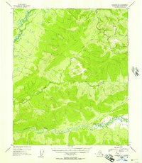
1953 Map of Livengood A-3
USGS Topo · Published 1958About this map
The Chatanika River winds through the southern reaches of this interior Alaskan landscape, which was mapped from aerial photography in the early 1950s. The terrain is characterized by high ridges and deep drainages, most notably defined by the prominence of Wickersham Dome in the northeast corner. Transportation through this remote section of the Fourth Judicial Division is anchored by the Elliott Highway, which follows the high ground of the Wickersham ridge system before descending toward the valley floors.
Find a feature on this map
12 named features on this map. Tap any name to fly to it.
Don’t see what you’re looking for? This feature index may not catch every label — zoom into the map to look around manually.
Map Details
Editions of this 1953 Livengood A-3 Map
4 editions found

Other maps of this area

1945 · Livengood
USGS Topo · 1:250,000

1949 · Fairbanks D-2
USGS Topo · 1:62,500

1949 · Fairbanks D-3
USGS Topo · 1:63,360

1949 · Fairbanks D-4
USGS Topo · 1:63,360

1950 · Fairbanks
USGS Topo · 1:250,000

1950 · Fairbanks D-3
USGS Topo · 1:63,360

1951 · Fairbanks
USGS Topo · 1:250,000

1951 · Livengood
USGS Topo · 1:250,000

1951 · Livengood B-2
USGS Topo · 1:63,360

1951 · Livengood A-4
USGS Topo · 1:63,360