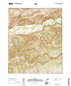
2017 Map of Livengood C-4 NE
USGS Topo · Published 2017About this map
Hess Creek and its southern tributaries wind through this interior Alaska landscape, defining the drainage patterns within the Yukon-Koyukuk region. This 2017 study illustrates a wild expanse where water is the primary architect of the terrain, as seen in the meandering path of Halfmoon Creek and the lower reaches of McHugh Creek. The map is structured around the Public Land Survey System boundaries for Townships 9 through 11 North, providing a clear coordinate-based view of the unpopulated backcountry. For those studying the hydrology of the Yukon River basin, the detailed elevation contours and wetland markings reveal the complex network of creeks that sustain this subarctic environment, offering a technical look at a landscape primarily defined by its riparian corridors and lack of established roads or infrastructure.
Find a feature on this map
9 named features on this map. Tap any name to fly to it.
Don’t see what you’re looking for? This feature index may not catch every label — zoom into the map to look around manually.
Map Details
Editions of this 2017 Livengood C-4 NE Map
This is the sole edition of this map. No revisions or reprints were ever made.
Other maps of this area

1945 · Livengood
USGS Topo · 1:250,000

1951 · Livengood
USGS Topo · 1:250,000

1951 · Livengood D-3
USGS Topo · 1:63,360

1952 · Livengood C-4
USGS Topo · 1:63,360

1953 · Livengood D-4
USGS Topo · 1:63,360

1954 · Livengood D-4
USGS Topo · 1:63,360

1954 · Livengood C-4
USGS Topo · 1:63,360
1954 · Livengood C-3
USGS Topo · 1:63,360
1954 · Livengood D-3
USGS Topo · 1:63,360

1956 · Livengood
USGS Topo · 1:250,000