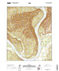
2017 Map of Livengood C-6 NW
USGS Topo · Published 2017About this map
The Yukon River dominates this interior Alaska landscape, carving a massive bend around Crescent Island and the elevated terrain of Maypole Hill. This survey reveals a complex hydrological network where numerous tributaries, including Twentymile Cr and Clinton Cr, feed into the primary river system. The presence of Hess Cr and McDermott Cr further illustrates the drainage patterns of the Yukon-Koyukuk region, showing the intricate relationship between the high ridges and the floodplains. The map provides a detailed view of the natural topography in its contemporary state, documenting the unchanged landforms and watercourses that define this part of the Alaskan wilderness.
Find a feature on this map
13 named features on this map. Tap any name to fly to it.
Don’t see what you’re looking for? This feature index may not catch every label — zoom into the map to look around manually.
Map Details
Editions of this 2017 Livengood C-6 NW Map
This is the sole edition of this map. No revisions or reprints were ever made.
Other maps of this area

1945 · Livengood
USGS Topo · 1:250,000

1951 · Tanana
USGS Topo · 1:250,000

1951 · Livengood
USGS Topo · 1:250,000

1956 · Tanana C-1
USGS Topo · 1:63,360

1956 · Livengood C-6
USGS Topo · 1:63,360

1956 · Livengood D-6
USGS Topo · 1:63,360

1956 · Tanana D-1
USGS Topo · 1:63,360

1956 · Livengood
USGS Topo · 1:250,000

1956 · Tanana
USGS Topo · 1:250,000

1960 · Tanana
USGS Topo · 1:250,000