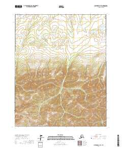
2017 Map of Livengood D-1 NE
USGS Topo · Published 2017About this map
Mt Schwatka rises as a prominent landmark in this northern interior region of Alaska, defining the topographic character of the southwestern corner of the quadrangle. The landscape is primarily shaped by an intricate drainage system, with Jefferson Cr winding through the central valleys and the headwaters of the W Fork Flat Cr and E Fork Flat Cr flowing toward the northern and eastern boundaries. This 2017 survey reflects a largely undeveloped wilderness within the Yukon-Koyukuk Census Area, where the topography transition from low-lying creek beds to significant elevations is meticulously documented through contemporary contour mapping. The absence of roads or established settlements emphasizes the remote nature of this subarctic terrain, making it a critical reference for understanding the natural hydrology and elevation gradients of the region.
Find a feature on this map
13 named features on this map. Tap any name to fly to it.
Don’t see what you’re looking for? This feature index may not catch every label — zoom into the map to look around manually.
Map Details
Editions of this 2017 Livengood D-1 NE Map
This is the sole edition of this map. No revisions or reprints were ever made.
Other maps of this area

1945 · Livengood
USGS Topo · 1:250,000

1951 · Fort Yukon
USGS Topo · 1:250,000

1951 · Livengood
USGS Topo · 1:250,000

1951 · Beaver
USGS Topo · 1:250,000

1951 · Circle
USGS Topo · 1:250,000

1951 · Circle D-6
USGS Topo · 1:63,360

1952 · Livengood D-1
USGS Topo · 1:63,360

1954 · Circle D-6
USGS Topo · 1:63,360
1954 · Livengood D-1
USGS Topo · 1:63,360

1955 · Circle
USGS Topo · 1:250,000