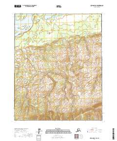
2017 Map of Livengood D-4 NW
USGS Topo · Published 2017About this map
The Yukon River defines the northern reaches of this interior landscape, where the massive waterway splits around large landforms such as Jackson Island and Theodore Island. This 2017 survey by the U.S. Geological Survey shows a transition from the riparian environment of the river valley to the steep, rising topography to the south. Jackson Slough and Jackson Lake mark the low-lying wetlands of the northern flats, while the terrain climbs toward the southeast. Small drainage patterns including Ross Creek (also labeled as Ross Cr) illustrate the hydraulic network feeding into the Yukon. The map is primarily characterized by its remote, uninhabited character, emphasizing natural landmarks and the legal boundaries of the Public Land Survey System without established roads or settlements.
Find a feature on this map
13 named features on this map. Tap any name to fly to it.
Don’t see what you’re looking for? This feature index may not catch every label — zoom into the map to look around manually.
Map Details
Editions of this 2017 Livengood D-4 NW Map
This is the sole edition of this map. No revisions or reprints were ever made.
Other maps of this area

1945 · Livengood
USGS Topo · 1:250,000

1951 · Livengood
USGS Topo · 1:250,000

1951 · Beaver
USGS Topo · 1:250,000

1952 · Livengood D-5
USGS Topo · 1:63,360

1953 · Livengood D-4
USGS Topo · 1:63,360

1954 · Livengood D-4
USGS Topo · 1:63,360

1956 · Beaver A-5
USGS Topo · 1:63,360

1956 · Beaver
USGS Topo · 1:250,000

1956 · Beaver A-4
USGS Topo · 1:63,360

1956 · Livengood
USGS Topo · 1:250,000