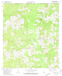
1981 Map of Liverpool
USGS Topo · Published 1981About this map
Easleyville and Liverpool anchor this St. Helena Parish landscape in the early 1980s, situated along a network of forest and farmland drained by the Tickfaw River and the Little River. The area is characterized by family-named landmarks and rural institutions that offer significant genealogical value, such as Old Venable Cem, Bates Cem, and Frazier Cem. Cultural centers like Red Bluff Ch and the New Zion Sch appear alongside industry markers like the Liverpool Lookout Tower and various Gravel Pits. Waterways like Cotton Patch Creek and Sandy Run define the local topography across the Mississippi Louisiana border. This survey captures a moment when traditional land use, represented by dozens of small cemeteries and country churches, persisted alongside modern utility corridors like the marked Pipeline.
Find a feature on this map
52 named features on this map. Tap any name to fly to it.
Don’t see what you’re looking for? This feature index may not catch every label — zoom into the map to look around manually.
Map Details
Editions of this 1981 Liverpool Map
This is the sole edition of this map. No revisions or reprints were ever made.
Other maps of this area

1940 · Roseland
USGS Topo · 1:31,680

1941 · Gilead
USGS Topo · 1:31,680

1941 · Chipola
USGS Topo · 1:31,680

1942 · Roseland
USGS Topo · 1:31,680

1942 · Liverpool
USGS Topo · 1:31,680

1942 · Gilead
USGS Topo · 1:31,680

1945 · Chipola
USGS Topo · 1:31,680

1950 · Kentwood
USGS Topo · 1:31,680

1950 · Greensburg
USGS Topo · 1:31,680

1953 · Natchez
USGS Topo · 1:250,000