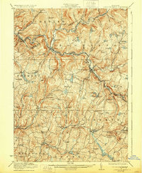
1923 Map of Livingston Manor
USGS Topo · Published 1928About this map
Livingston Manor serves as a central hub on this Catskills landscape, where the confluence of the Beaver Kill and Willowemoc Creek defines the local geography. In the early 1920s, the region was a significant corridor for both industry and early tourism, evidenced by the presence of a Dye Works near Cooks Falls and a Creosote Plant south of Roscoe. The Ontario and Western RR tracks follow the winding river valleys, providing vital transportation for the area's timber and chemical industries, such as the Acid Plant in the town of Rockland.
Find a feature on this map
89 named features on this map. Tap any name to fly to it.
Don’t see what you’re looking for? This feature index may not catch every label — zoom into the map to look around manually.
Map Details
Editions of this 1923 Livingston Manor Map
5 editions found

Other maps of this area

1901 · Margaretville
USGS Topo · 1:62,500

1904 · Margaretville
USGS Topo · 1:62,500

1909 · Monticello
USGS Topo · 1:62,500

1910 · Neversink
USGS Topo · 1:62,500

1911 · Monticello
USGS Topo · 1:62,500

1920 · Long Eddy
USGS Topo · 1:62,500

1920 · Damascus
USGS Topo · 1:62,500

1921 · Long Eddy
USGS Topo · 1:48,000

1921 · Livingston Manor
USGS Topo · 1:62,500

1922 · White Lake
USGS Topo · 1:62,500