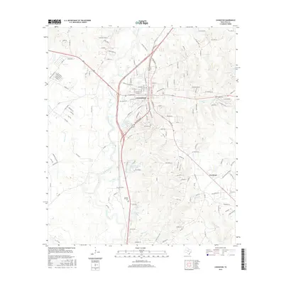
2016 Map of Livingston
USGS Topo · Published 2016About this map
Livingston serves as the focal point of this Polk County landscape, where the confluence of several creeks and small lakes defines the local geography. Significant water bodies such as Lake Thunderbird and Henderson Lake are interspersed with residential developments like Villagebrook and Lakeside Village Estates Lake. The drainage network, including Long King Creek, Choates Cr, and Tempe Creek, shapes the terrain around the central settlement. Local history is anchored by sites such as Forest Hill Cem, Restland Memorial Cem, and Peebles Cem, providing important landmarks for genealogical research. The map also captures the smaller community of Providence and the designated area of Stallion Station, reflecting the mix of established town infrastructure and rural outskirts in East Texas.
Find a feature on this map
143 named features on this map. Tap any name to fly to it.
Don’t see what you’re looking for? This feature index may not catch every label — zoom into the map to look around manually.
Map Details
Editions of this 2016 Livingston Map
This is the sole edition of this map. No revisions or reprints were ever made.
Other maps of this area

1954 · Beaumont
USGS Topo · 1:250,000

1955 · New Willard
USGS Topo · 1:62,500

1957 · Beaumont
USGS Topo · 1:250,000

1958 · Livingston
USGS Topo · 1:62,500

1960 · Blanchard
USGS Topo · 1:24,000

1960 · Camilla
USGS Topo · 1:24,000

1961 · Onalaska
USGS Topo · 1:24,000

1984 · Soda
USGS Topo · 1:24,000

1984 · Beaumont
USGS Topo · 1:250,000
1984 · Livingston
USGS Topo · 1:24,000