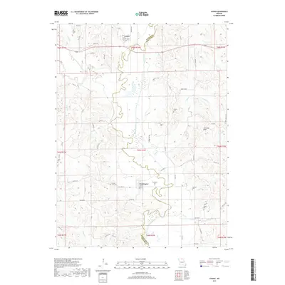
2017 Map of Livonia
USGS Topo · Published 2017About this map
The Chariton River meanders through the heart of northern Missouri, tracing a path that divides Putnam Co and Schuyler Co. Along this waterway, the small settlements of Livonia and Worthington anchor the landscape, connected by a network of rural routes like State Hwy W and Co Hwy H. The map reveals a land defined by its drainages, including Elm Cr, Wildcat Cr, and Brush Cr, which carve through the high ground of White Oak Ridge. Family history is deeply rooted here, evidenced by numerous burial grounds scattered across the townships, such as Speak Cem in the north and Cooper Cem near Sand Cr. These sites, along with landmarks like Kerby Timber, provide a detailed geography of the local communities and their enduring connection to the river valley.
Find a feature on this map
61 named features on this map. Tap any name to fly to it.
Don’t see what you’re looking for? This feature index may not catch every label — zoom into the map to look around manually.
Map Details
Editions of this 2017 Livonia Map
This is the sole edition of this map. No revisions or reprints were ever made.
Other maps of this area

1911 · Queen City
USGS Topo · 1:62,500

1912 · Green City
USGS Topo · 1:62,500

1913 · Queen City
USGS Topo · 1:62,500

1914 · Green City
USGS Topo · 1:62,500

1939 · Centerville
USGS Topo · 1:62,500

1941 · Centerville
USGS Topo · 1:62,500

1954 · Centerville
USGS Topo · 1:250,000

1957 · Centerville
USGS Topo · 1:250,000

1958 · Centerville
USGS Topo · 1:250,000
1974 · Green City NE
USGS Topo · 1:24,000