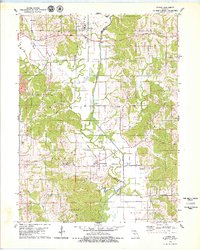
1979 Map of Livonia
USGS Topo · Published 1979About this map
The Chariton River meanders through the heart of this landscape along the Putnam and Schuyler County line, defining the agricultural character of the region in the late 1970s. The settlement of Worthington sits near the riverbanks, where an Old RR Grade hints at the former rail infrastructure that once linked these rural communities. To the north, the village of Livonia serves as a local hub, surrounded by a patchwork of timbered ridges and cleared fields. Genealogists will find a high density of family and community burial sites, including the Worthington Cem, Speak Cem, and Pleasant Home Cem. The terrain is marked by distinctive elevations like White Oak Ridge and a network of named waterways such as Shoal Creek and Winkler Creek, which flow toward the Salt River in the southern reaches of the quadrangle.
Find a feature on this map
33 named features on this map. Tap any name to fly to it.
Don’t see what you’re looking for? This feature index may not catch every label — zoom into the map to look around manually.
Map Details
Editions of this 1979 Livonia Map
This is the sole edition of this map. No revisions or reprints were ever made.
Other maps of this area

1911 · Queen City
USGS Topo · 1:62,500

1912 · Green City
USGS Topo · 1:62,500

1913 · Queen City
USGS Topo · 1:62,500

1914 · Green City
USGS Topo · 1:62,500

1939 · Centerville
USGS Topo · 1:62,500

1941 · Centerville
USGS Topo · 1:62,500

1954 · Centerville
USGS Topo · 1:250,000

1957 · Centerville
USGS Topo · 1:250,000

1958 · Centerville
USGS Topo · 1:250,000
1974 · Green City NE
USGS Topo · 1:24,000