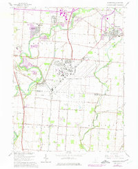
1964 Map of Lockbourne
USGS Topo · Published 1975About this map
Lockbourne Air Force Base dominates the central landscape of this mid-century Franklin County survey, reflecting the era's significant military footprint south of Columbus. The base sits within a grid of established agricultural and rail corridors, where the Chesapeake and Ohio and Norfolk and Western railroads facilitate industrial transport near Lockbourne and Obetz. To the west, the Scioto River and Big Walnut Creek converge, defining a drainage basin characterized by scattered gravel pits and river-bottom terrain. Residential expansion is evident in developments like Hamilton Meadows, while older local landmarks such as Watkins Cem, St Josephs Cem, and Township High Sch provide essential anchor points for genealogists tracing family roots in Hamilton and Madison townships. The map also records early recreational sites, including Scioto Downs and Camp St Joseph, alongside small rural communities like Duvall and Shadeville.
Find a feature on this map
55 named features on this map. Tap any name to fly to it.
Don’t see what you’re looking for? This feature index may not catch every label — zoom into the map to look around manually.
Map Details
Editions of this 1964 Lockbourne Map
3 editions found
Other maps of this area

1911 · Era
USGS Topo · 1:62,500

1913 · Era
USGS Topo · 1:62,500

1914 · Circleville
USGS Topo · 1:62,500

1923 · West Columbus
USGS Topo · 1:62,500

1925 · East Columbus
USGS Topo · 1:62,500

1925 · West Columbus
USGS Topo · 1:62,500

1943 · Era
USGS Topo · 1:62,500

1943 · Circleville
USGS Topo · 1:62,500

1943 · East Columbus
USGS Topo · 1:62,500

1947 · Columbus
USGS Topo · 1:250,000