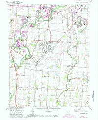
1964 Map of Lockbourne
USGS Topo · Published 1985About this map
Rickenbacker Air National Guard Base dominates the central landscape of this central Ohio region, illustrating the mid-century expansion of military aviation infrastructure south of Columbus. The confluence of Big Walnut Creek, Alum Creek, and Blacklick Creek defines the local hydrology, with many small communities such as Lockbourne and Groveport positioned along these waterways and the adjacent rail lines. The transportation network is heavily influenced by the Norfolk and Western and Chesapeake and Ohio railroads, which facilitated the movement of goods through the Hamilton and Madison townships. Local civic life is evidenced by the presence of the Township High Sch, several rural houses of worship like St Vincents Ch, and the Scioto Valley Grange. This survey, updated with 1980s data, reveals the transition from agricultural land to residential developments like Hamilton Meadows.
Find a feature on this map
46 named features on this map. Tap any name to fly to it.
Don’t see what you’re looking for? This feature index may not catch every label — zoom into the map to look around manually.
Map Details
Editions of this 1964 Lockbourne Map
3 editions found
Other maps of this area

1911 · Era
USGS Topo · 1:62,500

1913 · Era
USGS Topo · 1:62,500

1914 · Circleville
USGS Topo · 1:62,500

1923 · West Columbus
USGS Topo · 1:62,500

1925 · East Columbus
USGS Topo · 1:62,500

1925 · West Columbus
USGS Topo · 1:62,500

1943 · Era
USGS Topo · 1:62,500

1943 · Circleville
USGS Topo · 1:62,500

1943 · East Columbus
USGS Topo · 1:62,500

1947 · Columbus
USGS Topo · 1:250,000