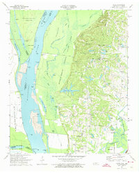
1970 Map of Locke
USGS Topo · Published 1974About this map
Meeman-Shelby State Park Forest dominates the bluff lands above the river, where the Mississippi River shifts between Tennessee and Arkansas. The map illustrates a complex riparian landscape of chutes, sloughs, and secondary lakes such as Poplar Tree Lake, Willow Lake, and Brinkley Bayou. Along the high ground of Chickasaw Bluff No 3, small rural communities and family-named roads like Piersol Road and Sylvan Road mark the settled interior. Local history is anchored by landmarks like the Jeter Sch and several country churches, including Mt Pisgah Ch and Oaklawn Ch. Near the southern edge, the industrial footprint of north Memphis begins to appear with Firestone Park and the Radio Towers (WDIA), showing the transition from the river-bottom timberlands to the expanding city. Numerous river landings like Cigarette Landing and Bullpen Landing point to the era's active river navigation and levee maintenance.
Find a feature on this map
94 named features on this map. Tap any name to fly to it.
Don’t see what you’re looking for? This feature index may not catch every label — zoom into the map to look around manually.
Map Details
Editions of this 1970 Locke Map
2 editions found
Other maps of this area

1916 · Memphis
USGS Topo · 1:62,500

1925 · Memphis
USGS Topo · 1:48,000

1927 · Memphis
USGS Topo · 1:62,500

1931 · Jericho
USGS Topo · 1:62,500

1939 · Jericho
USGS Topo · 1:62,500

1939 · Memphis
USGS Topo · 1:62,500

1942 · Millington
USGS Topo · 1:62,500

1952 · Jericho
USGS Topo · 1:62,500

1953 · Memphis
USGS Topo · 1:250,000

1955 · Memphis
USGS Topo · 1:62,500