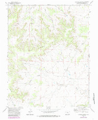
1972 Map of Lockwood Arroyo
USGS Topo · Published 1985About this map
The Bear Springs Hills dominate the northern terrain of this Las Animas County landscape, where complex drainage patterns are defined by several seasonal watercourses. The network of the Middle Bear Springs Arroyo, East Bear Springs Arroyo, and Sheep Canyon Arroyo illustrates the erosional forces shaping this part of Colorado. In the southern half of the map, the Big Arroyo Hills and Lockwood Arroyo anchor a region marked by significant elevation changes, though the area remains largely undeveloped. Human activity is evidenced primarily by industrial transit, most notably the Pipeline and its associated Pipeline Road which cut across the southern topography. This 1970s record, updated in the mid-1980s, highlights a period of remote land management where infrastructure was limited to utility corridors and scattered Springs.
Find a feature on this map
11 named features on this map. Tap any name to fly to it.
Don’t see what you’re looking for? This feature index may not catch every label — zoom into the map to look around manually.
Map Details
Editions of this 1972 Lockwood Arroyo Map
4 editions found
Other maps of this area

1891 · Timpas
USGS Topo · 1:125,000

1891 · Apishapa
USGS Topo · 1:125,000

1891 · Mesa De Maya
USGS Topo · 1:125,000

1892 · Elmoro
USGS Topo · 1:125,000

1893 · Apishapa
USGS Topo · 1:125,000

1893 · Elmoro
USGS Topo · 1:125,000

1893 · Mesa de Maya
USGS Topo · 1:125,000

1894 · Timpas
USGS Topo · 1:125,000

1897 · Elmoro
USGS Topo · 1:125,000

1897 · Apishapa
USGS Topo · 1:125,000