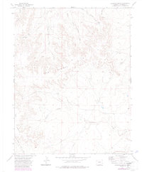
1972 Map of Lockwood Arroyo
USGS Topo · Published 1985About this map
Lockwood Arroyo cuts through this high plains landscape of Las Animas County, where the dry drainage networks define the topography of the Bear Springs Hills. This 1970s survey, updated in the mid-1980s, reveals a terrain shaped by erosion and seasonal water flow, characterized by complex arroyo systems including Middle Bear Springs Arroyo and East Bear Springs Arroyo. The land use appears primarily focused on ranching and infrastructure, evidenced by a solitary Windmill and the presence of a significant Pipeline corridor cutting across the relief. To the southwest, the Big Arroyo Hills rise near Taylor Arroyo, showing the characteristic "arroyo" landscape where deep channels have been carved into the Colorado plains. The map records several unpaved routes, most notably Pipeline Road, which provides access through this sparsely developed region of southern Colorado.
Find a feature on this map
11 named features on this map. Tap any name to fly to it.
Don’t see what you’re looking for? This feature index may not catch every label — zoom into the map to look around manually.
Map Details
Editions of this 1972 Lockwood Arroyo Map
4 editions found
Other maps of this area

1891 · Timpas
USGS Topo · 1:125,000

1891 · Apishapa
USGS Topo · 1:125,000

1891 · Mesa De Maya
USGS Topo · 1:125,000

1892 · Elmoro
USGS Topo · 1:125,000

1893 · Apishapa
USGS Topo · 1:125,000

1893 · Elmoro
USGS Topo · 1:125,000

1893 · Mesa de Maya
USGS Topo · 1:125,000

1894 · Timpas
USGS Topo · 1:125,000

1897 · Elmoro
USGS Topo · 1:125,000

1897 · Apishapa
USGS Topo · 1:125,000