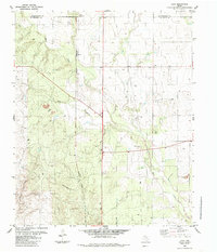
1984 Map of Loco
USGS Topo · Published 1985About this map
The boundary between Collingsworth and Childress County bisects this 1980s landscape, where the small community of Loco and its nearby counterpart New Loco anchor a region defined by cattle ranching and scattered industrial operations. The steel rails of the Burlington Northern railroad cut a straight path through the territory, running parallel to the winding course of Buck Creek. This transit corridor reflects the area's role in moving livestock and local resources across the Texas Panhandle during the late 20th century.
Find a feature on this map
13 named features on this map. Tap any name to fly to it.
Don’t see what you’re looking for? This feature index may not catch every label — zoom into the map to look around manually.
Map Details
Editions of this 1984 Loco Map
This is the sole edition of this map. No revisions or reprints were ever made.
Other maps of this area

1954 · Plainview
USGS Topo · 1:250,000

1958 · Plainview
USGS Topo · 1:250,000

1960 · Loco
USGS Topo · 1:62,500

1961 · Estelline
USGS Topo · 1:62,500

1964 · Wellington
USGS Topo · 1:24,000

1964 · Dodson
USGS Topo · 1:24,000

1964 · Rolla
USGS Topo · 1:24,000
1984 · Arlie
USGS Topo · 1:24,000

1984 · Estelline NE
USGS Topo · 1:24,000
1985 · Garden Valley
USGS Topo · 1:24,000