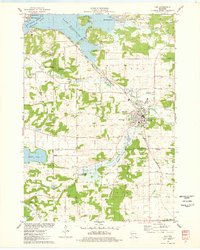
1975 Map of Lodi
USGS Topo · Published 1978About this map
Lodi serves as the focal point of this mid-1970s landscape, where the Chicago and North Western railroad cuts a diagonal path toward the Wisconsin River. To the northwest, the river widens significantly into Lake Wisconsin, creating a distinctive shoreline that defines the settlements of Harmony Grove and Okee. The terrain is characterized by prominent elevations like Gibraltar Rock and Pine Bluff, with the former preserved within Gibraltar Rock County Park.
Find a feature on this map
46 named features on this map. Tap any name to fly to it.
Don’t see what you’re looking for? This feature index may not catch every label — zoom into the map to look around manually.
Map Details
Editions of this 1975 Lodi Map
This is the sole edition of this map. No revisions or reprints were ever made.
Other maps of this area

1890 · Madison
USGS Topo · 1:62,500

1892 · Madison
USGS Topo · 1:62,500

1895 · Baraboo
USGS Topo · 1:62,500

1901 · Poynette
USGS Topo · 1:62,500

1904 · Madison
USGS Topo · 1:62,500

1906 · Madison
USGS Topo · 1:62,500

1907 · Cross Plains
USGS Topo · 1:62,500

1908 · Baraboo
USGS Topo · 1:62,500

1909 · Cross Plains
USGS Topo · 1:62,500

1957 · Madison
USGS Topo · 1:250,000