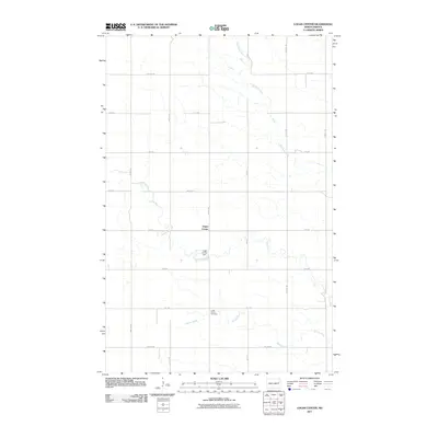
2011 Map of Logan Center
USGS Topo · Published 2011About this map
Logan Center and its surrounding agricultural landscape are defined by the meandering courses of the Goose River and the Little Goose River as they wind through eastern North Dakota. The settlement itself sits at the intersection of 9th Ave and 46th St NE, serving as a quiet anchor for the local farming community. To the south, the Logan Center Dam regulates the water levels of the river system, while Spring Creek flows eastward toward the Goose River. This landscape is marked by a strict section-line road grid, including 13th Ave NE and 43rd St NE, which facilitates transport across the fertile plains. The Logan Center Cemetery remains a significant site for genealogical research, offering a physical record of the families who established and maintained the agrarian heritage of this region.
Find a feature on this map
21 named features on this map. Tap any name to fly to it.
Don’t see what you’re looking for? This feature index may not catch every label — zoom into the map to look around manually.
Map Details
Editions of this 2011 Logan Center Map
This is the sole edition of this map. No revisions or reprints were ever made.
Other maps of this area

1936 · Larimore
USGS Topo · 1:62,500

1939 · Niagara
USGS Topo · 1:62,500

1952 · Grand Forks
USGS Topo · 1:250,000

1956 · Grand Forks
USGS Topo · 1:250,000

1963 · Niagara SW
USGS Topo · 1:24,000

1963 · Larimore SW
USGS Topo · 1:24,000

1963 · Larimore West
USGS Topo · 1:24,000
1963 · Niagara
USGS Topo · 1:24,000

1963 · Logan Center
USGS Topo · 1:24,000

1966 · Grand Forks
USGS Topo · 1:250,000