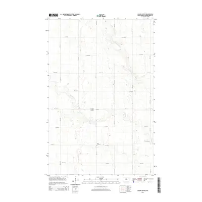
2014 Map of Logan Center
USGS Topo · Published 2014About this map
Logan Center and its surrounding agricultural landscape are defined by the winding paths of the Goose River and the Little Goose River in this 2014 survey of Grand Forks County. The terrain is a structured grid of rural roads, including 9th Ave NE and 46th St NE, which intersect near the small community. This edition captures the localized infrastructure of the Red River Valley, featuring the Logan Center Cem south of the main settlement and the privately operated Morten Airport situated along the eastern bank of the Goose River. The map provides a clear record of the area's hydrology, showing where Spring Cr meanders through the southern sections of the quadrangle before joining the larger river system. This survey is particularly useful for documenting contemporary land use and property access in a region primarily dedicated to large-scale farming.
Find a feature on this map
20 named features on this map. Tap any name to fly to it.
Don’t see what you’re looking for? This feature index may not catch every label — zoom into the map to look around manually.
Map Details
Editions of this 2014 Logan Center Map
This is the sole edition of this map. No revisions or reprints were ever made.
Other maps of this area

1936 · Larimore
USGS Topo · 1:62,500

1939 · Niagara
USGS Topo · 1:62,500

1952 · Grand Forks
USGS Topo · 1:250,000

1956 · Grand Forks
USGS Topo · 1:250,000

1963 · Niagara SW
USGS Topo · 1:24,000

1963 · Larimore SW
USGS Topo · 1:24,000

1963 · Larimore West
USGS Topo · 1:24,000
1963 · Niagara
USGS Topo · 1:24,000

1963 · Logan Center
USGS Topo · 1:24,000

1966 · Grand Forks
USGS Topo · 1:250,000