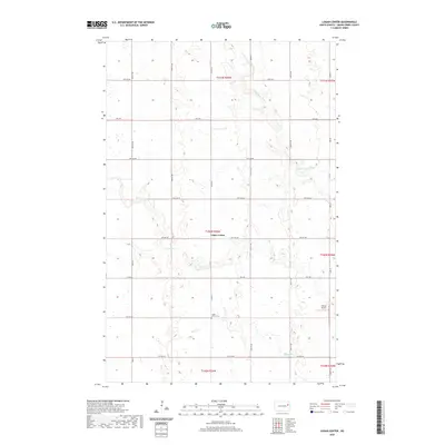
2020 Map of Logan Center
USGS Topo · Published 2020About this map
Logan Center and its surrounding agricultural landscape in Grand Forks County are defined by the winding paths of the Goose River and Little Goose River. This 2020 survey illustrates the organized grid of township and range lines typical of the Red River Valley region, with primary local travel corridors like Co Rd 16 and Co Rd 6 bisecting the prairie. For those researching local history, the Logan Center Cem and the nearby Morten Airport represent key community landmarks in this sparsely populated stretch of North Dakota. The drainage patterns of Spring Cr further shape the geography of the southern sections, where the land transitions between several township boundaries including t150n r56w and t149n r56w.
Find a feature on this map
23 named features on this map. Tap any name to fly to it.
Don’t see what you’re looking for? This feature index may not catch every label — zoom into the map to look around manually.
Map Details
Editions of this 2020 Logan Center Map
This is the sole edition of this map. No revisions or reprints were ever made.
Other maps of this area

1936 · Larimore
USGS Topo · 1:62,500

1939 · Niagara
USGS Topo · 1:62,500

1952 · Grand Forks
USGS Topo · 1:250,000

1956 · Grand Forks
USGS Topo · 1:250,000

1963 · Niagara SW
USGS Topo · 1:24,000

1963 · Larimore SW
USGS Topo · 1:24,000

1963 · Larimore West
USGS Topo · 1:24,000
1963 · Niagara
USGS Topo · 1:24,000

1963 · Logan Center
USGS Topo · 1:24,000

1966 · Grand Forks
USGS Topo · 1:250,000