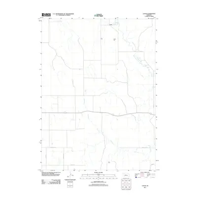
2011 Map of Logan
USGS Topo · Published 2011About this map
Logan sits along the northern edge of this Nebraska landscape, where the South Loup River winds through the hills of Logan County. The terrain is defined by the winding course of Sand Creek, which flows southeast across a region marked by isolated holdings like Bailey Ranch and Marr Ranch. This 2011 survey captures a rural environment where development is largely confined to a grid of local roads, including River Rd and the mislabeled Norht Co Line Rd. Elevation changes are most prominent at Kings Hill, providing a view over the surrounding drainage basins. The map illustrates a contemporary western ranching landscape where historical land use patterns persist through family-named landmarks and a sparse network of section-line roads such as N Smith Rd and N Withuhn Rd.
Find a feature on this map
11 named features on this map. Tap any name to fly to it.
Don’t see what you’re looking for? This feature index may not catch every label — zoom into the map to look around manually.
Map Details
Editions of this 2011 Logan Map
This is the sole edition of this map. No revisions or reprints were ever made.
Other maps of this area

1948 · Linscott
USGS Topo · 1:62,500

1950 · Linscott
USGS Topo · 1:62,500

1951 · Hoagland
USGS Topo · 1:62,500

1954 · North Platte
USGS Topo · 1:250,000

1956 · North Platte
USGS Topo · 1:250,000

1957 · North Platte
USGS Topo · 1:250,000

1967 · North Platte
USGS Topo · 1:250,000

1972 · Logan
USGS Topo · 1:24,000

1972 · Arnold
USGS Topo · 1:24,000
1972 · Gandy
USGS Topo · 1:24,000