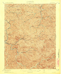
1913 Map of Logan
USGS Topo · Published 1913About this map
Guyandot River serves as the central artery for this coal-country landscape in the years before the Great War. The Chesapeake and Ohio railroad follows the river's winding path through the Logan district, connecting a series of narrow valleys where early 20th-century industry began to take root. Settlements like Pecks Mill, Peach Creek, and McConnell are positioned at critical junctions between the water and the steep terrain, while further inland, the mapping of Dingess Run and Rum Creek reveals the dense network of tributaries that defined local access. This survey, supervised by state geologist I.C. White, details the topographical isolation of places like Clothier and Sharples along the Boone County and Logan County line, capturing the region's character just as the extractive economy was transforming the Appalachian backcountry into a bustling industrial corridor.
Find a feature on this map
55 named features on this map. Tap any name to fly to it.
Don’t see what you’re looking for? This feature index may not catch every label — zoom into the map to look around manually.
Map Details
Editions of this 1913 Logan Map
3 editions found

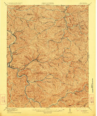
Other maps of this area

1887 · Warfield
USGS Topo · 1:125,000

1891 · Oceana
USGS Topo · 1:125,000

1891 · Warfield
USGS Topo · 1:125,000

1892 · Huntington
USGS Topo · 1:125,000

1893 · Oceana
USGS Topo · 1:125,000

1898 · Huntington
USGS Topo · 1:125,000

1898 · Oceana
USGS Topo · 1:125,000

1899 · Charleston
USGS Topo · 1:125,000

1902 · Midkiff
USGS Topo · 1:62,500

1907 · Midkiff
USGS Topo · 1:62,500