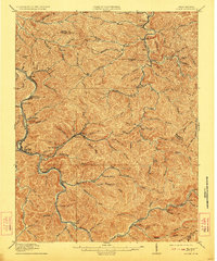
1913 Map of Logan
USGS Topo · Published 1923About this map
Logan serves as the focal point for this survey of the northern coalfields of West Virginia, where the C and O railway network dictates the pattern of development. The topography is defined by the steep divides of Buffalo Mtn and heights like Godby Knob, with settlements like Clothier, Sharples, and Accoville following the narrow valley floors. The landscape reflects the industrial expansion of the early twentieth century, as rail spurs from the Chesapeake and Ohio reach deep into drainages like Peach Creek and Rum Creek to serve local coal operations. This map records the precise boundary lines between Boone and Logan counties, providing a clear view of the winding Guyandotte River before later urbanization altered many of these valley-bottom communities.
Find a feature on this map
92 named features on this map. Tap any name to fly to it.
Don’t see what you’re looking for? This feature index may not catch every label — zoom into the map to look around manually.
Map Details
Editions of this 1913 Logan Map
3 editions found

Other maps of this area

1887 · Warfield
USGS Topo · 1:125,000

1891 · Oceana
USGS Topo · 1:125,000

1891 · Warfield
USGS Topo · 1:125,000

1892 · Huntington
USGS Topo · 1:125,000

1893 · Oceana
USGS Topo · 1:125,000

1898 · Huntington
USGS Topo · 1:125,000

1898 · Oceana
USGS Topo · 1:125,000

1899 · Charleston
USGS Topo · 1:125,000

1902 · Midkiff
USGS Topo · 1:62,500

1907 · Midkiff
USGS Topo · 1:62,500